 |
| Upper and lower Lake Mary from Anderson Mesa (2020) |
Anderson Mesa Passage
As of July 2023, I have completed the Anderson Mesa Passage, which I seem to have hiked in three installments over about thirteen years. I will be describing this passage from south to north, instead of chronologically.
July 11 and 13, 2023
On July 11, we hiked from Mayflower Spring to West Weimar Springs Road. The day became hotter in the two miles between the passage start at Mayflower Spring and West Weimar Springs Road. Still the same mix of open park and ponderosa woods as we skirted the hillside north of Mormon Lake.
 |
| The explanatory plaque (2023) |
On July 13, we continued the hike from West Weimar Springs Road to Lake Mary Road (Chris, me) and from Horse Lake Trailhead to Lake Mary Road (me). The day's morning temperatures were in the 70s and partly cloudy--perfect hiking weather. After 10 a.m., temperatures rose to the 80s, and the sky turned mostly clear. At least half of the section we hiked on July 13 followed an old railroad grade, which had actually begun in the first two miles of the passage, hiked July 11th. About 1/10 of a mile northeast of West Weimar Springs Road, we encountered an explanatory sign, near a clear section of the railroad grade, where old sleepers remained in pattern. According to the sign, a railroad serving the logging industry and weekend Flagstaff vacationers operated here in the 1920s, most likely between 1924 and 1927. This section continued the landscape of open woods and sunny meadows; apparently the area is also open range--we encountered some groups of grazing cows near the trail.
Though the Arizona Trail is clearly marked, we did encounter one lost family group from the Pine Grove Campground, who believed they were following an out-and-back nature trail. Just past the turnoff to the Pine Grove campground, there is an underpass beneath the Pine Grove access road, though a half a mile farther on, there is no underpass under the Lake Mary Road. Apparently one has to scamper across to the AZT gate on the other side.
Once we had completed the return hike from Lake Mary Road, Chris drove me up to the Horse Lake Trailhead, from which I hiked down (for approximately 20 minutes) to the gate at Lake Mary Road. The forest road to the trailhead is a bit of a backcountry superhighway, with trailers and heavy trucks, as well as cars, at regular intervals. The trail from Lake Mary Road tends uphill and generally parallels the forest road. As a result, there was at least one concerning encampment (complete with pirate flag and tarp-covered fenced enclosure) between the trail and the forest road, maybe 40 yards from the trail at its closest point.
 |
| Intermittent water on Passage 30 (2010) |
May 29, 2010
(me, Richard Duerden, Ranger the dog)
 |
| San Francisco Peaks from Anderson Mesa (2010) |
 |
| Horse Lake Trailhead (2010) |
Chris, me. Weather--sunny and dry, high 70s to mid 80s.
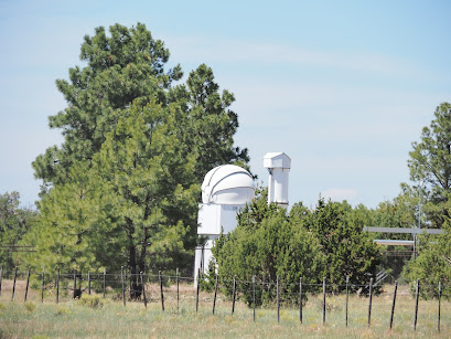
This was our second day of car camping at Marshall Lake. On this day, we took the Arizona Trail from the trail junction at the south end of the lake further south on the Anderson Mesa Passage, hiking approximately 5 miles from the trail junction. We ended at around Vail Lake at the Lakeview Campground Trail turnoff. The trail was clearly marked, and took us around the Perkins Telescope and the Prime Lake refuge area, which was fenced off. Approaching the edge of Anderson Mesa, there were great views of Upper and Lower Lake Mary.
 |
| Arizona Trail Gate at the northern terminus of Passage 30 (2020) |
Here is the link to the passage map: https://aztrail.org/wp-content/uploads/2018/01/30_AndersonMesa.pdf
 |
| Perkins Telescope Complex, Passage 30 (2020) |


No comments:
Post a Comment