Thursday, July 30, 2020

Arizona Trail: Passage 25

[A quick note:  Until this iteration of the Arizona Trail maps, this passage (Whiterock Mesa) was originally two:  Whiterock Mesa and Hardscrabble Mesa.  From this point on, each passage will be a numeral lower than the original passage numbering.]


Whiterock Mesa

January 19-20, 2002  Twin Buttes TH to LF Ranch (out at the Baby Doll TH).  Richard, Doug, Nathaniel, me.

1/19—Reached Twin Buttes at 11:15, took Trail 14 essentially SE.  Weather in the 60’s with high clouds.  Began in juniper scrub at 5800 feet.  If the map is correct, we descended a total of 1400 feet over the day, to Whiterock Springs at 4400 feet.


Great hiking, with ever-improving views.  Occasionally we lost the trail, which is lightly marked with cairns, probably for horse packers (the cairns were low and squat – hard to see from the ground, but probably easy from a horse, and they seemed too far apart).

As we descended, we actually got more spruce-type vegetation (it now strikes me that I’ve seen juniper scrub into and out of the Verde Valley on I-17 at about 5-6000 feet)1/19—Reached Twin Buttes at 11:15, took Trail 14 essentially SE.  Weather in the 60’s with high clouds.  Began in juniper scrub at 5800 feet.  If the map is correct, we descended a total of 1400 feet over the day, to Whiterock Springs at 4400 feet.

Great hiking, with ever-improving views.  Occasionally we lost the trail, which is lightly marked with cairns, probably for horse packers (the cairns were low and squat – hard to see from the ground, but probably easy from a horse, and they seemed too far apart).


As we descended, we actually got more spruce-type vegetation (it now strikes me that I’ve seen juniper scrub into and out of the Verde Valley on I-17 at about 5-6000 feet)

White Rock Springs is below a steep climb down, in the spruce.  Though it doesn’t look like it, there’s a great campsite east off the trail about 100 yards down or so from the spring.  Water flow at the spring was small, but there were two small full tanks.  We didn’t filter, just boiled, but the water had a lot of dissolved lime.  Cloud cover dissipated overnight, taking the temp down to 25 degrees or so.  It warmed up quickly after sunup.  We got underway at about 9:30 a.m.

 Great hiking!  The day was perfectly clear, and warmed up to about 65 degrees.  Most of the day was level, along a ridge that took us to within 2 miles of LF ranch.  There’s significant grazing for a couple of miles along that ridge with well(!)-used stock tanks built.  They would work for emergency water, but aren’t appetizing.  The trail drops just past Fuzzy’s Point (with a small marker).  From the point, you get a panoramic view of the Mazatzals and the cut-butte valley of the East Verde.  It is easy to see why LF Ranch is still inhabited – the setting is ideal.  But you’re really cut off from amenities.

A quick drop off the ridge brings you to an old ranch site that must have been earlier inhabited by Indians (saw 2 potsherds).  Polk Spring, on the bank of Rock Creek at the ranch site, really pumps.  There’s a small clear creeklet that flows into Rock Creek.  The East Verde was running low (too low to float), so it was an easy ford (thank goodness for a stick).  Ate lunch on the gravel bar at 12:30.  Trail 14 skirts the ranch.  It has a cutoff to the Baby Doll trailhead road, which we didn’t take.

The Road’s a good surface, but has some really steep slogs.  It always seems too hot when I hike it.  Got to the truck by 3:15.  Didn’t finish the car shuttle until approx. 6:30 (but we rested at the trailhead for about ½ hour).


Hardscrabble Mesa to Pine Trailhead

10-12-03:  Richard Sarah, Chris, Ranger, me

 Lovely hike along power lines.  Saw Blue Juniper, manzanita, Oak Spring running (dying), Ponderosa pines.  The bark beetle is changing the ecosystem.

[No pictures that I can find]

Wednesday, July 29, 2020

Arizona Trail: Passage 24

Red Hills Passage

[Continuing my notes on a trip with Richard, May 15-18, 1999]


5/17

Camped at Brush Spring – badly used by cattle and horse people.

5/18

Very overgrown spur trail out to LF Ranch.  Glad we were going downhill.  Hot (100+degree) hiking from LF Ranch to the Doll Baby Trailhead.  When we got there, we had to fix a flat tire on the truck, which had happened about a mile from the trailhead.


[As with the previous entry, whenever I digitize my film slides, I will add pictures.]

Arizona Trail: Passage 23

Mazatzal Divide Passage

This is the first passage of the Arizona Trail that I hiked.  It's also my first multiday packing trip with Richard.  He has the HikeAZ handle Mazatzal, because his project during the end of the 1990s and beginning decade of the 2000's was to hike as much in the Mazatzal Wilderness as possible.  At the time, I was not aware of the Arizona Trail, but this was the beginning.

This is also the second extended backpacking trip that I had taken in Arizona, the first being a traverse of the Mazatzals with Maxie in 1998 (which overlapped this trip from Horse Camp Seep to the Park).  In that trip, we'd traversed the wilderness west to east from Sheep Bridge Trailhead to City Creek (not the smartest direction of travel).  The year after this inaugurated an approximately 13-year annual backpacking or backcountry trip tradition among the three of us.  The Superstitions passage, as well as part of the Four Peaks passages were done as annual group trips.

_____________________________________________________________________

But here are the notes from May 15-18, 1999, with Richard.


5/15 Mt. Peeley to Windsor Seep

Weather:  Clear, high 70’s low 45 degrees.  Fair amount of initial climbing, but with good vistas.  We could see the Mt. Peeley Road until 2 p.m.  (Road surface good, but narrow and steep.  Many recreational people.)

Approx. 4 p.m. we found Bear Spring.  It was running decently and the spring had been improved with concrete.  We did not check Fisher Spring.

Widnsor Seep 5 p.m.  Great views (as usual).  Very tired.  At approx. 5:30 two younger men came from the Barnhart.  They seemed nice, but fired their gun several times in their camp at night, the last (2) times at 11:30.  Nervous night, but perhaps this was just cowboy stupidity.

5/16

Did not check Windsor Seep, since I would have had to pass our marksmen’s (?) camp.  We were walking by 8:45.  Nice views, but uneventful, to Chilson.  At Chilson, I was expecting the tanks to be full.  They weren’t.  I followed the pipe to the spring, which was running decently.  Lunch at Chilson, met a dayhiker, and filled the bottles at Chilson spring.  As it turned out, we needn’t have spent that extra 45 minutes.  About a mile down the trail, we came to some (slightly) running pools, right across the trail.  We sponged off here.

At Horse Camp Seep, water is available, but not immediately apparent.  We decided to camp here (at 3:30) because it was just a bit longer to get there, and because we knew there was water at Horse Camp Seep.  That means a longer day tomorrow, but I’ll be backtracking some of the trail I did last year.

Been feeling funny this trip, a bit.  Just nervous – about water, about gun-toting campers – even though so far everything’s been fine.  I put it down to severe exertion (though the trails aren’t as hard as last year, I’m not in as good of shape).

(If I ever digitize my film slides from this trip, there will be pictures.)


Arizona Trail: Passage 22

Saddle Mountain Passage

I have done all but about 3 miles at the beginning of this passage in several dayhikes and one Mazatzal trip, in which we followed the Arizona Trail from the Mormon Grove Trailhead to Squaw Flat.  The other trips were taken some time in the mid-2000s, with a variety of people--Richard, Jeannie, Sarah, Taylor, Julianne, Chris--and with Ranger, the dog.

Here are the notes from the 2001 Mazatzal Mountains trip with Richard and Maxie:


March 30, 2001

Mormon Grove Trailhead to Squaw Flat (4 ½ miles)

½ mile in – connect to the AZ Trail.  Stay on AZ trail to Squaw Flat.  Temps. 80’s, but comfortable with light breeze.

White balls of live oak bloom smelling of cinnamon and must.  Spice on the breeze.  The trail is an old mining road.  Story Mine – 1 mi. off trail, just before Squaw flat.  Squaw Flat – plenty of water, running streams, pines.  Northwest Youth Corps camp at the best spot in Squaw Flat.  14 people?  Trail maintenance for 6 weeks.

Our campsite (1/4 mile farther) is also good, just not so big.  It’s at a creek-seep confluence.  Good manzanita fire (Manzanita Camp).
____________________________________________________________________


I've found a set of pictures taken September 24, 2006 that seem to depict the trip from the Cross F Trailhead (on the old SR 87 near Sycamore Creek)  to somewhere above Squaw Flat, and maybe as far as Mt. Peeley Trailhead, though that may be another trip.


Tuesday, July 28, 2020

Arizona Trail: Passage 21


[I've done this passage, with the exception of about 6 miles in the middle, in two trips, one in 2005, just below, and one on November 18, 2018, below that.]

 From 4 Miles North of Lone Pine Saddle to FR 429 in the 4 Peaks Wilderness. March 6-8, 2005.  With Richard, Maxie, and Ranger.  Circa 48-65 degrees, rain and overcast.


3/6/05

From 4 mi. north of Lone Pine Saddle to Shake Spring in 4 Peaks Wilderness w/ Maxie and Richard.  Threatening rain on and off from the time we left the house.  It was cold—48 degrees during the day. Some sprinkles, but no serious rain.

We made “Ranger Camp” near a flowing drainage just below Shake Spring.  Great camp. Why "Ranger Camp"?  Well, Ranger’s still great on the trail, but didn’t have enough exercise, even with the dog backpack.  He was a nuisance in camp until I used the tie-outs.

Lots of 4-wheelers on the road to Lone Pine.

Remembering embers of story around a dying campfire.
 
3/7/05

Granite Camp (Granite Spring).  We went from Shake Spring around Granite Mountain.  The AZT has been rerouted here—it no longer goes straight over the top of Granite Mountain.  But it’s no longer 6-7 miles, more like 7-8.  Very tired. Ranger did very well, and is settling down in camp.

Too many dipsy-doodles through drainages. 

But great views—
4 Peaks, Anchas, tip of the Rim (w/snow), Roosevelt Lake.

Also, Maxie reminded me that Ranger got stuck under a downed burned pine today, and had to slip out of his pack to get out from under.


From SR 87 to FR 422.  November 18, 2018.  With Chris, Richard and Sarah.  (An approximately 12 mile out-and back.)

Nice weather, probably mid-60s and clear.  The primary purpose of the trip was for Richard to reconnoiter the approach to a point on the Arizona Trail for a cattle gate.  In the process, we walked part of the passage, and took a quick side trip to Bushnell Tanks.

Nice weather, probably mid-60s and clear.  The primary purpose of the trip was for Richard to reconnoiter the approach to a point on the Arizona Trail for a cattle gate.  In the process, we walked part of the passage, and took a quick side trip to Bushnell Tanks.


Arizona Trail: Passage 20


From Forest Road 429, West of Roosevelt Dam, to the Frazier Trailhead.
December 8, 2002.  With Chris, Richard, and Sarah.  Weather:  55-70 degrees, clear.

Total hike from FR 429 trailhead to SR188:  6.72 mi.  Beginning from 3750 ft. to 2225 ft.  Desert scrub/grassland to Upper Sonoran.

Clear skies, great vistas of Fish Creek Hill/Apache Lake to the south, The Sierra Ancha and Roosevelt lake (what’s left of it in the drought) to the north.  Easy hiking on dirt roads and new trails.  Little elevation gain, but about 1000 feet of full loss.  Covered springs and seeps, but little evidence of grazing.  I think the [Pine Mountain] passage begins at the trailhead where we stopped, and goes about 7 miles to Lone Pine Saddle [actually, it goes all the way to SR-87].  There are supposedly Indian ruins up there.

Easy hike across ridges, for the most part, until lunch at 12:30.  We hung around on the ridge until about 1, then climbed down steeply to SR 188.  There’s a radio tower up there that’s not connected to any wires, so you can’t figure out what it does.  This tower overlooks Roosevelt dam, now off limits because of 9/11.  There’s a suspension bridge over the mouth of the Salt River in front of the Dam.  It looks like a metal rainbow with streams of rain (cables) coming down from the bow.

Richard and Jim:  3.56 miles to Frazier Trailhead.

We’d parked the car at the pullout before the bridge, but the AZT continued beyond the bridge.  Richard and I hiked over the bridge (very little vehicular traffic), then up a ravine to a low ridgeline.  This section skirts the town of Roosevelt, and winds through all the drainages.  Though this was listed on the AZT description as a 2-mile trail, going in and out of drainages actually made it 3.5 or more miles.  The landscape is badly cow-scarred, and some of the trail dirt is loose and fine.  It’s Sonoran landscape, more used than that across the bridge.  Interesting things we saw:  an old rusted U.S. Dept. of the Interior sign in the shape of a shield, probably dating from the 1930’s, designating the area a wildlife refuge.  We wanted to take it, but that would have been vandalism.  Also, I stepped off into the air on a narrow part of the trail, and really banged a knee.  Luckily the paloverde and jojoba broke my fall.  The trail ended at the Frazier Trailhead, where Richard, Maxie, and I had come out on the ill-fated trip last Spring Break, when I had a 102 degree fever.


Sunday, July 26, 2020

Grandpa Does the Arizona Trail: Passage 19

Superstition Wilderness with Maxie and Richard


March 14-16, 2002

(Here are the verbatim notes from the trip, along with some original pictures, on a crude digital camera.  At the end is a little more analytical statement about the passage.)


3/14
Arrived Rogers Trough at 10:40 a.m. (actually, began hiking).  Day—bright and hazy, with 20 mph wind on the ridges (cool, crisp – takes me back to windy ridges in NH White Mtns).  Made Reavis Saddle in 2 hours for lunch (50-60 degrees, 20 mph winds).  Songs:  “Oh What a Beautiful Morning” (Oklahoma!!?!) as we’re getting ready to roll.  “The Road Goes Ever On,” J.R.R. Tolkien—while climbing to Reavis Saddle, with Maxie and me trying to remember verses.  Flowers:  not many, but yellow marigold-type, 2 purple, 1 many petaled, 1 4-petaled, 1 white daisy-type flower (bursage?), 1 light purple daisy-type flower.  Animals: 3 mule deer in wash (from car), 1 lizard, quail.  Plants: manzanita, agave, Alligator juniper on saddle.

3/15
7 a.m., 25 degrees, water frozen.

Last night – Sherry Camp at Pine Creek.  Sherry and cigars.  Seems to be plenty of water – Reavis, Pine Creek (big pool) Walnut Spring (decent, smelly pool).  Sunny, 50 degrees on Two Bar Ridge before Klondike.  11:30 a.m., called Chris from the ridge and got the answering machine.  Animals:  quail, scorpion, lizard.  Indian ruin 200 yards from Walnut Spring.  Dropoff and climb after Klondike Spring area (didn’t find the spring itself) is a killer.  Temperature on the ridge after Klondike probably 45-50 degrees, 
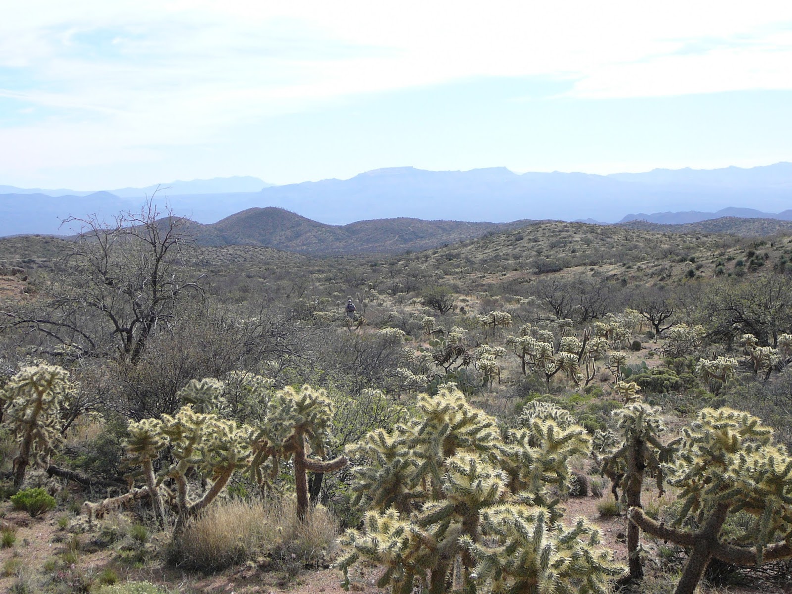
with 25 mph winds.  Gorgeous panoramas while hiking on the ridge.  Did not find either the tank or North Pole Spring on the trail before a climb to the wilderness boundary.  Long, approx. 10 mi. day.  About a mile and a half from the wilderness boundary, we picked up a hunting dog with a swollen right front leg.  Found the group of stock tanks marked on the map outside the wilderness boundary.  Only one had significant water in it.  Hiked approx. 1 mile down a 4x4 road to get to the tank, and camped next to it at about 6:30 p.m.  So tired that we ate gorp for dinner, and weren’t able to filter any water.

3/16
In the morning, Bill Mercer, a puma hunter from Globe, came out looking for his dogs (3), of which one was found.  Another came in after he had left in the morning.  The mud in the water buckets had not settled out in the morning; Richard’s filter was clogged after just a little while of pumping it.  My filter pumped about 2 liters before becoming very hard to use.  However, my filter did not get the dissolved clay completely out.  It started out like chocolate milk and came out of my filter a light grey-brown.  It was a lesson in the limitations of filters, and in what one might be willing to drink.  We made coffee and oatmeal from the filtered water, and cached ½ liter as emergency backup in my pack.  Two and a half miles later, we found Cottonwood Spring, which had clean water.

The thing that makes this hike hard occurs after Klondike Spring (which we didn’t find because we didn’t look for it).  To that point, water had been plentiful and easy to find, even in a drought year.
But in the unnamed creek canyon, things get dry.  The last water on the trail that we saw was Walnut Spring until a tank at the wilderness boundary at FR 83.  Also, this canyon is steep both ways, down and up.  Though the elevation loss and gain is about the same as from Rogers Trough to Reavis Saddle, it’s a lot steeper, especially on the North (climbing) side.  With fewer switchbacks, this climb really takes it out of you.  Just a slog.
We ascended to Two Bar Ridge.  Do breathtaking views and suddenly colder temperatures make up for that slog?  Maybe, if you planned it right.  We may not have.  Richard wanted to make it to the edge of the wilderness area by nightfall.  We soldiered on, but a lot of oomph was taken out by the long descent and climb (we’d passed a horse/donkey skeleton halfway up the climb).
We didn’t have time to look for the tank marked on the FS wilderness map in Tule Canyon.  It wasn’t really apparent from the trail.  We got to the edge of the wilderness area at 6 p.m. (10 a.m. to 6 p.m.), saw a tank in the valley to the right and camped there.

Tank Camp—a learning experience.

         1.  There are some kinds of dirt that pumps can’t handle.  I’ll have to ask Phil F. whether mud can be in solution (it can).  Darkness caught us making camp, so we saved the water purification for the following morning, after Richard had clogged his pump doing less than a half pint of purification.  Gorp, jerky, water, wine, and bed.
2.                  The tanks at this end were pretty dry.  There’s actually a metal tank on top of the ridge above the trail.  We were too late and too tired to investigate, but it’s possible that the tanks in this valley are filled from there.

                2. Tank water doesn’t settle out, and can’t be strained through a handkerchief to get the brown out.  The best I could do with my First Need filter was to move from dark brown to light brown.  We used it anyway for coffee and oatmeal.

According to the Beartooth Wilderness map of the Supers it’s 17.7 mi. point to point from Rogers Trough to the Roosevelt side wilderness boundary.  Richard pegged it at 20 mi, as did the women who wrote On the Arizona Trail.  (Of course, they also said that it was 9.5 miles between water points, which is almost certainly false.  But it’s not clear whether or not they’re counting Cottonwood Spring, outside the wilderness boundary, as the next water.)

Next morning, it wasn’t quite 2 miles to Cottonwood Spring, according to the map, but it felt longer.  Good water at Cottonwood and plenty of it, all the way to where we left the trail, near the marina and visitors center on Roosevelt Lake.  There are many spurs out on this trail; we took the Frazier Trailhead spur, and so had a hard time hooking up with Chris.  I’d been under the weather for more than a day by that time; I didn’t know until I took my temperature at home that I’d been hiking with a 101 degree fever.  Turns out that Chris’s sickness was the flu.

Summary:  A great trip, but too hard the way we did it.  Aside from not getting sick, the best way to do it would be to camp at Reavis on night 1, Klondike Spring (if it can be found) on night 2, and a full day to FR 83 on day 3.


 Certainly the women who wrote On the Arizona Trail are wrong when they call the trail difficult to follow and overgrown.  I’ve experienced much worse in the Mazatzals.  But water is critical, and it turns out that we didn’t check the one most critical aspect of a comfortable hike:  Klondike Spring.


Addendum, 11/26/2022


I'm just back from my first try at giving back to the Arizona Trail. We hiked in on November 18, 2022 from the Campaign (used to be Upper Horral?) Trailhead, up the Reavis Gap Trail for about 3.5 miles, then another mile south on the Arizona Trail, to Pine Creek. We set up camp to do trail work on the approximately 2 miles south of our campsite. The work crew consisted of 10 people besides me, including the two horse packers who supplied the crew with fresh water and packed in some camp supplies.

Great weather, not as cold as I had feared. It had been about 6 years since my last overnight backpack (though there had been plenty of base camp/dayhikes on the trail in the years since). So, I was hindered initially by my lack of packing fitness and the fact that I'd packed too much (hefting packs at the end of the trip, I found that mine was heavier by 5-10 pounds, without the tools we'd carried in). One thing I hadn't expected was the problem of hiking in multifocal glasses instead of contacts. That made me noticeably less secure in my footing. Beyond that, I was the only one with an external frame pack, which I'd mispacked at the beginning.

However, I found my fitness in the two days of trail maintenance (lopping overhanging branches from the trail and grubbing out live oaks, catclaw acacia, and yucca that had encroached on the trail. Hard but satisfying work, though even with long sleeves and gloves I had plenty of "rabid chipmunk" scars (scratches from thorns on arms and hands). The weather was perfect, and the company was great. I'd do it again easily.


Thursday, July 23, 2020

Grandpa Does the Arizona Trail: Passage 18


February 2, 2023 with Chris

Continuing with my project to fill the gaps hiking the trail, Chris and I hiked out-and-back from the Picketpost Trailhead south of U.S. 60, to an Arizona Trail gate about 4 miles from the trailhead. We were less than 1/2 mile from the spot we started from in 2005. It was a perfect Arizona day, with no snakes, unlike last time (too cold). This stretch of the passage trends uphill toward Whitford Canyon, with about 2 miles on a ridgeline that allows great views of Picketpost Mountain (pictured above), the Dripping Springs Mountains, and (unfortunately) what looks like a tailings field, perhaps from the new Resolution mine. About 2 miles into the hike, the trail crosses the (f-ing) slurry pipe that will service the new mine; at least the pipe runs parallel to an existing railroad track. The flowers are just beginning to bloom on a few cacti, and we saw some quail, deer, and rabbits (plus some hawks in the air).

Queen Creek is running at the crossing, and things look lush and green. We stopped at mile 4.71 of the hike (according to RouteScout), at an AZT gate that is clearly marked on the AZT passage maps.

Going under U.S. 60 from the Picketpost trailhead, we may have passed the oldest AZT gate on the trail (pictured). Who can tell?


April 10, 2005 with Chris, Richard, Sarah, Ranger

On this day, we hiked approximately one third of this passage, north of U.S. 60, primarily in Whitford Canyon, from the first junction with FR 650 to about a mile and a half before the trail intersects the road into the Rogers Trough Trailhead (a total of about 3 miles away).

Here is the original text concerning the day:

AZT--Whitford Canyon

Purple hedgehog cactus blooms, lupine, orange poppies (a few), blooming burdock, yellow and white daisy-like flowers.
_____________________________________________________________________

I notice that I didn't mention probably the outstanding feature of the trip, which was the number of rattlesnakes we saw on the trip:  3.  We saw one on the road from the car, and two while on the trail, including one at our lunch stop, coiled in a dead pine about 2 feet from where Chris was eating lunch.  Thankfully, the dog didn't notice, being intent on her sandwich.  After I warned them away from the striking area, we realized that we needed to get the dog snake-trained, which we did later in the spring.


Arizona Trail: Passage 17

February 18-19, 2001 with Richard (Continued) [Alamo Canyon Passage]

By the end of February 18, we reached the current route of the Arizona Trail, outside of the BLM wilderness.  Here are the original notes:

2/19
7 a.m. 34 degrees F.
Cold but humid night.  Good campsite.  This is the last water until a tank marked on the map near some mine workings.  Then, no water until coming off the jeep trail past Orphan Boy mine.  Panoramic views of Weaver’s Needle, Supers, Florence, Superior, rugged mtns.  Today showed that there was a time when these mountains were much more inhabited than they are now.  We passed at least two major mine workings, besides Orphan Boy.

Glowing gold, orange
Purple stalks, crossed petals
Lupines, poppies, sunlight

Hillside carpeted
Golden poppies and bursage
Rich.

Here's the (current) passage map [not the route we followed]:  https://aztrail.org/wp-content/uploads/2018/01/17_AlamoCanyon.pdf

Arizona Trail: Passage 16

Backpacking February 18-19, 2001, with Richard

We hiked the old route of the trail, through the BLM wilderness off Battleaxe road.  In the event, we probably covered about a quarter of what is now the Gila River Canyons passage, in distance, though we probably intersected the actual passage very near its ending.  The original narrative follows:


2/18

7:45 – Leave Jim’s house
8:35 – Picketpost Trailhead [where we dropped the car for the end of the backpack].  Dirt Rd. (f231) to gravel-paved cross-road.  Circa 2 mi. to developed trailhead.  

9:35 – as far as we decided to go on Battleaxe Rd.  Bad washouts, narrow sections.  Lucky we didn’t have Chris drive us.  The AZ Trail narrative is more accurate than the map.

5 p.m. – set up camp circa mile 8 (AZ Trail map overestimates distances), on tributary of Telegraph Canyon, where 2 jeep trails come together.  Lots of water early in the day, but after we dropped down into the central canyons, the only water was running in the wash/jeep tracks.

Biggest problem of the morning – route-finding past a riparian area and corral in the BLM wilderness area.  The riparian area was impossible to tell, and when the trail climbed out onto a ridge, the cairns were few and irregular.  Outside the wilderness area, the jeep roads are like superhighways.

Saturday, July 18, 2020

Arizona Trail: Passage 15

I partially hiked this passage twice in 2005, with Richard, Sarah, Chris, and our dog Ranger.  The first hike occurred on February 13, from Kelvin, south of the Gila River, toward Ripsey wash, an out-and-back of about 2 1/2 miles.  Though we took no pictures of this stretch, and the stretch at the time was not GPS waypointed, I did make a few notes (all the photos are from the second expedition, which was sunny).

First, I noted that (for us at the time) the stretch was not good for mountain biking, being steep and not well-marked.  This was high, relatively open, Sonoran desert, with lots of cholla.  There were cattle grazing on the open range.  The best thing about the trip was the weather--there was water running after two days of rain.  We began under cloudy skies, which then moved to partly cloudy at mid-day, back to cloudy in the afternoon.  Not many days like that in Arizona.

Also--mud puddles.  Ranger became a two-toned Lab after lying down in one, a mile from the trailhead.  Also--water running over over rocks down a wash absolutely disappears (like going down a hole) into the sandy wash bottom below the rock stratum (granite and intrusive basalt).

For the second trip (with the same contingent), on December 11, 2005, we dropped a vehicle at the river, to pick up later.  This time, we got about 3 1/2 miles up the trail to the river.

The biggest problem was finding the turnoff for Ripsey Wash.  We'd meant to get closer to the trail, but the road was so bad that we stopped at the fenced, posted area that marked the beginning of some state trust land.  We hiked on the remaining road to the trail junction.

Lots of fine sand on the roads and in the wash. There was significantly different vegetation in the wash canyons than on the tableland above.  I think the canyon vegetation was Lower Sonoran desertscrub.
Anyway, the day was cloudy and cold, and we saw two vehicles on the trip, one in Ripsey Wash.  The driver of the truck in the wash had a Queensland Heeler, and called Ranger "fat."

Something itched in that wash.  Chris and I both picked up  some irritation.


Friday, July 3, 2020

Arizona Trail: Passage 14


March 21-23, 2014, with Richard (day-hiking and car camping.)

We planned this as a day-hiking and car camping trip.  On the first day, we had driven to the Tiger Mine Trailhead, where the passage begins, and left my car there.  We then parked Richard's car at the  Camp Grant Wash intersection with the trail, to be picked up the evening of the next day, and hiked south.  Interestingly, this is one of the more remote long stretches of the trail, with no paved road crossings until Kelvin, almost 50 miles away (Freeman Road is dirt at the midpoint).

The route was dry, though there were a couple of tanks.  We saw one through-hiker, and one bicyclist that day (another bicyclist the next day).  Antelope mountain is the picture above; to the side is a point near the Tiger Mine Trailhead.

 We ate at a pizza place in San Manuel, then camped out at the Freeman Road trail access (about 300 yards off the road itself.  We were disturbed all night with people target shooting about a mile away, with automatic weapons.  Just before we were about to break camp, they stopped, at full dark.

The next day, we hiked to Richard's car in Camp Grant Wash.  It was a beautiful day, though also hot, with few water spots.  We felt lucky to have dayhiked these areas with plenty of water.

It turns out that I had driven into Camp Grant Wash with Chris, in the red truck, with my bike in the back, to ride the trail.  I don't think I did, however.  But the photographic evidence is clear--Richard and Sarah drove their car as well (see below left--that's Richard, and my truck with the bike).

Thursday, July 2, 2020

Arizona Trail: Passage 12


 On March 19th and 20th, 2016, Richard, Maxie and I hiked Oracle Ridge, most of Passage 12 of the Arizona Trail.  We started from the intersection of the "back way" up Mount Lemmon and the paved road through Summerhaven.  Though there was snow on the top of the mountain, the weather was temperate all the way to the top.

We may have made a mistake, since we traveled from Phoenix to the top of Mount Lemmon on the first day.  Going from about 1000 feet above sea level to approximately 10,000 in one day might have been too much; it would probably have been better to sleep a day at altitude before doing a 12-mile hike to American Flag Trailhead, where we had left the second car.  I also, perhaps, shouldn't have bought that spicy trail mix.

Anyhow, the trail down from near the summit was mostly clear, but at times steep and rocky.  The panoramas show the majestic views.  On Oracle Ridge, we had a view of Biosphere 2.

The way was simply long, and when we reached the American Flag trailhead, I know that at least I was exhausted--too exhausted to really eat.  We were all so tired that instead of camping on the back way up to Mount Lemmon, we instead opted for a motel.

On the next day, we took the Mount Lemmon Highway to the top, hiked around a bit near the summit, saw Summerhaven, and did not complete the trail down Pusch Ridge, as we'd intended to do.  So, we were not quite done with Passage 12, but got most of it.  This summer (2020), the stretch we hiked burned.  The last picture is the fire damage from a previous fire on Pusch Ridge.  I'm sure more of the route looks like that now.


Here's the passage map:  https://aztrail.org/wp-content/uploads/2018/01/12_OracleRidge.pdf