Saturday, October 1, 2011

Mesa Canals 7: Val Vista Road to Granite Reef Dam on the Southern Canal


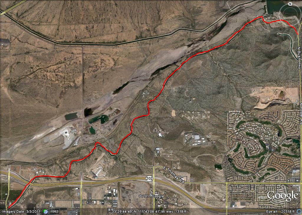
In a way, this is the big one: 4.9 miles from the junction of the Southern Canal and Val Vista Road to a bridge at the spillway of the dam. From the bridge to the Bush Highway on Granite Reef Dam Road is a further .8 mile. The 5.7 total miles recorded on my odometer track perfectly with the 5.66 miles of the Google Earth Route. It seemed longer. Wait. That didn't sound right--the surface is often rough on the north side of the canal (which you want to use, for reasons that will become clear later), but there is great scenery and no major road crossing.

Early in the ride, which I undertook in the early morning, the canal crosses under the 202 freeway. A bobcat was ambling down the path, coming out from an orange grove where he'd almost certainly spent the night. Past the orange grove on the north side of the 202, the canal goes through Pima reservation land on one side. On the other side are other isolated homesteads (including one fenced one with interesting signs) and a gravel operation. When the path gets close to the dam, the south side of the canal is cut down through the rock of some slopes, and there's no trail on that side. At the dam spillway, I saw cows grazing; a bridge allowed me to cross the canal to Granite Reef Dam Road, which leads out to the Bush Highway (coming the other direction last week, there are a number of Keep Out signs on Granite Reef Dam Road, but the road itself is not blocked).

The Bush Highway climbs steeply back up to McDowell Road, which is a good route back west to Mesa.

Mesa Canals 6: Connecting the Dots

This is a bit out of place, but I wanted to connect a couple of routes that I've previously described. In Mesa Canals 5, I pointed out that I'd wanted to go North on the Roosevelt Canal past McDowell, but that the path didn't look open. However, it actually was (see the picture below). On (apparently) August 13, I set out to complete the mile of canal path that I hadn't done.


First, the total route is approximately .8 of a mile (by my odometer). The first portion of the path goes past orange groves and some kind of industrial yard. After a while, one comes upon some relatively rural property east of Val Vista Road. On the road there are subdivision gates, but on the canal path, there seem to be a couple of dirt roads in, with some ranches essentially fronting onto the path. Here's the water tower of one.


At .6 of a mile, there's a fence, which can also be gotten through. It leads down a road to an octagonal pumping station at the junction between the Roosevelt and Southern Canals. About 200 yards west, the trail meets Val Vista Road. Here's the Google Earth picture of the path. By the way, this route connects up with other route described in Mesa Canals 5, and Mesa Canals 7.


Last week, I tried to connect one other route. About 3 weeks ago, I'd ridden the Southern Canal all the way out to Granite Reef Dam. That is documented in Mesa Canals 7. But I'd started that trip at the Val Vista intersection of the Southern Canal. I wanted to document the Southern Canal connector between my Mesa Canals 2 description to McDowell Road, and the big Granite Reef Dam trip. Anyhow, the north side of the canal is open to traffic. It runs just below the works of an industrial gravel operation, the Val Vista water treatment plant, and some subdivisions north of McDowell. The scenery looking north (from near the top of the mesa) is interesting, across orange groves and incoming subdivision sites south of the 202, with the McDowell Mountains, Red Mountain, and even Four Peaks in the distance. The road has little elevation change, and is well-graded.