Wednesday, September 1, 2021

Maricopa Trail: Gilbert-Queen Creek-San Tan


Here's the Maricopa Trail online map for this section.  The first part of this ride is documented in the Mesa Canals 14 post (a ride to Bergie's Coffee Shop in downtown Gilbert).  The map above goes from the turnoff point to Bergies on the Consolidated Canal, to where the Trail crosses the Loop 202 South.

Most of this part of the trail winds with the canal through new subdivisions.  The road crossings are generally safe, though there is at least one complicated crossing, I believe at Chandler/Williams Field Road, where it is necessary to wait for two stoplights.

Gilbert has landscaped and graded these canal paths well, and it is possible to ride on either side most of the way.  North of Elliot Road to the Bergies turnoff, however, riders will want to be on the West Bank of the canal; the east bank is blocked by some SRP structures.

At one time, much of this section must have looked like the section on the Pima-Maricopa Indian Community:  mostly farm fields and wide vistas.  Now, however, it is far more closed-in with surrounding subdivisions.  It is well-used, but not to the overly-trafficked point.

Click here for a short video on You Tube that gives a quick sense of this section of the trail (my action cam videos are still in test/learning mode).


Tuesday, August 31, 2021

Maricopa Trail: Scottsdale-Granite Reef-Mesa and Filling Blanks


Finally, the second installment:  this one covers most of the Scottsdale-Granite Reef-Mesa map (for which I'm now embedding links in the appropriate posts), though the Prelude post has more of it, and I still need to do the bit from Granite Reef at Bush Highway-Power Road to Usery Mountain Park (that will be added when the weather cools).

The two maps above show my routes on April 9, 2021 when I finally rode again the section of the South Canal from its intersection with the Eastern Canal at McDowell Road to the intersection point with the Consolidated Canal, and a new (to me) section from Hayden Road to the Mesa Landfill (on tribal land near SR 87).   Both of these routes were done with Chris; if I can ever get my action cam to work right, I'll have pictures and video, which I'll post. 

The top section is one that I've done before in the Mesa Canals series (posts 7 and 12), but it was good to do again.  The The South Canal is the north side of the fork intersection with the Consolidated Canal, and immediately goes down a steep slope.  Once down the slope, there is an underpass at Gilbert Road, before the canal grade goes through Lehi.  There's a surface crossing at McKellips Road, as there is again at Horne street (watch the traffic).  The trail skirts Mesa's Park of the Canals, before connecting with the Consolidated Canal just north of Brown Road.

The bottom map is a ride done May 31, 2021.  Most of this stretch is over the Pima-Maricopa Indian Community, and skirts farm fields, where we saw much wildlife, including a rattlesnake and some burrowing owls.  As with the South Canal stretch between McDowell and Granite Reef, this route feels like the country, though roads cross and there are other travelers (including riders of gravel bikes, who are apparently using the Maricopa Trail as a shortcut from Scottsdale to SR 87 (the Beeline Highway).  We stopped just before riding past the landfill, which was not aesthetically pleasing.  According to the map, the Arizona Canal skirts the northern edge of the landfill before curving back down to a surface crossing (!) of the Beeline Highway.  See the Prelude post for the Maricopa Trail section southeast of the Beeline.

So, this fills in one blank of this section (the big curve to the Consolidated Canal).  The next blank is the trail (near Hawes Loop) that leads to Usery Mountain Park.


Tuesday, May 4, 2021

Maricopa Trail: The Prelude (Scottsdale-Granite Reef-Mesa)


The Scottsdale-Granite Reef Map

This is starting more slowly and weirdly than I thought it would.  When the Maricopa Trail was announced several years ago, I started collecting maps, planning to do a project in the next year to cycle the whole trail.  But things change on the Maricopa County Parks website:  The Maricopa Trail connects in spots to the Sun Circle Trail, which I first became aware of around 8 or 9 years ago, and the maps have been changing and going away from their original website homes to different places.  So, now, the first part of my task is downloading the new maps and ordering them in my personal file.  Here's the current website home of the maps:  https://www.maricopacountyparks.net/park-locator/maricopa-trail/trail-maps/.

Chris and I thought we'd be able to cycle most of this together as well, but in October 2020, Chris injured her knee and has been rehabbing since.  She can ride now (with her new new bike [a long story]) but is not up to the multi-mile trails or the rougher park routes yet.

So . . . on March 28th of this year, we planned a shakedown trip of about 4 3/4 miles one-way from the Granite Reef Dam parking area on Power Road/The Bush Highway to the crossing of SR 87 (the Beeline Highway) along the Arizona Canal.  Here's a short test video (this was also a shakedown of my new action cam).  What we found:  the trail follows the southern shore of the canal all the way to SR 87.  It's also a relatively complicated and not well-signed route from the Bush Highway parking area past Granite Reef Dam, over a bridge, across the dam spillway, to the Arizona Canal.  Once on the canal path, however, the desert is open and relatively deserted (though we met several gravel bike riders, apparently cruising over from the Beeline).  Great views of the Pima-Maricopa native lands, as well as Red Mountain in the distance.  There's little noticeable elevation gain or loss.  It was also a lovely, sunny day, though a little hot (this is probably too hot for riding in full summer).

On April 11, we took another ride out the South Canal from near our home.  Starting from just past Gilbert road, the actual distance we rode on the Maricopa Trail was about 3.8 miles.  I've biked this stretch many times (see my Mesa Canals entries--7 and 12), as well as searching for the marker for the historic Lehi Crossing (Mesa Canals 1).  This stretch has more traffic, but also gets the Mesa city dweller out of town and into the scenery.

And so it begins (with a whimper) . . . my attempt to ride around the whole of the Maricopa Trail by the Spring of 2022.  The next challenge:  map reading.  It turns out the the spur from Granite Reef to Usery Mountain Park goes through a Tonto National Forest area locally known as Hawes Loop.  Should be interesting, though maybe not in the heat and snake mating season.

Thursday, April 29, 2021

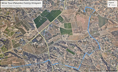
Bike Touring with Google Maps--Palumbo Family Vineyard, Temecula, CA


We took our mountain bikes to California when visiting family after getting vaccinated.  The main purpose of the trip was to see the grandkids under controlled outdoor conditions.  Since we could not stay with family, we found a beyond-excellent AirBnB, Rusty Fork Ranch, in the wine country around Temecula, about half an hour from an in-law family cabin.  It was just a wild hair--bike to vineyards as we had during the wine-country tour that we had done in Sonoma in 2018.  On that trip, though, despite my extensive route-planning and saving routes on Strava (not a complete success), we sometimes found ourselves on unacceptably busy roads.

So, this time, Chris said, in essence, "No riding on arterial roads with lots of traffic."  As well, the shoulders on many California roads are not what I would consider sufficient.  This wine country is also rolling, with a number of steep short hills (over 10% gradient).  So we asked our Rusty Fork host, Tyler, for a recommendation--a winery reachable by gravel road, off arterial highways, around 5 miles from the Rusty Fork.  He suggested the Palumbo Family Winery, which included a stretch on the gravel Via Fernando.

Instead of using paper maps or an app like Strava, I just entered Via Fernando on Google Maps.  That indicated a route that included only one quarter-mile stretch of arterial road (with shoulders--the Anza Road section on the map above).  Google Maps worked effectively, getting us to Via Fernando nicely; at that point, I entered the address of Palumbo Family Vineyards, and charted a course from the current location.  Perfect.

If I'd known how relatively easy using Google Maps was to find decent routes while biking, I'd have used it more extensively in 2018.  Especially helpful was the verbal direction function, which I turned on, and just put my phone back in my pocket.  It let me know what turns were coming up, and which way to go.

The Palumbo Family Vineyard was excellent in itself:  we arrived just as the tasting room opened (under COVID rules, there's only a pickup of glasses/bottles at the window, then tasting outside only, socially-distanced), and treated ourselves to a flight of reds, from which we picked two bottles to buy. Superb! (I won't tell which wines here; if you like reds, try them for yourselves.)

Just a few notes on the route:  Mountain bikes or e-bikes might be in order if you don't care to climb grades up to 11% with a high-geared road bike; though the grades are short, they are quite steep, so gear down early.  Also, be sure to bring enough water to make it for about 5 miles (the actual route is 8.95 miles from and back to the Rusty Fork).  Palumbo has water available, but there's nothing in between.  Be sure to bring something to pack the wine back in!


Tuesday, March 16, 2021

The Month of Moons Project

 The Kit:  the Olympus OMD EM5 Mark iii, paired with the M.Zuiko 14-150 f4-5.6 Zoom

What the project was:  I would take at least one picture per day of the moon for a complete lunar cycle (28 days).

That seems simple.  But in execution, it turned out to be more complex, and involved a fair amount of equipment learning and testing, as well as learning post-processing techniques.  The 12 pictures and videos in this post are the products of this learning curve.  In this collection are single shots of the moon in various phases, composite and high-resolution shots, and some astrophotography, blue-hour and daylight pictures.

My first day of photographing was January 28.  I was trying out a (cheap) telephoto extender; the lens blur and distortion made it unusable, though some elements appeared to be loose in the housing.  I practiced compositing as well, and believe I posted one composite on Instagram, but don't believe it deserves further reproduction.  That experience led me back to the 14-150 f4 zoom that I used for the rest of the project.

My first usable picture, and one that is part of the final products I want to showcase, I took on January 29.  

As I look at it, it now feels a bit dark, but I felt that the effect of the focused moon through the tree was nice.  This early night showed me two things:  I needed to know where the moon would be at any point, so that I could compose shots, and I needed a standard set of camera settings to take the shot.  There are a number of good websites dealing with photographing the moon (interestingly, as a bright object, f11 and 1/125 of a second on a tripod actually work), and a number of ephemerides (moon/sun position) apps are available.  There is a set of online calculators for various shooting scenarios (primarily timelapse) at the Photo Pills website, which also is paired with an app.  I, however, chose a free moon/sun Ephemeris app for Android.

I began getting good shots that night, and made plans for a second composite photograph, one that would show the phases of the moon on consecutive nights.  Here it is, from January 30 through February 1.


I like this one, and it inspired me to attempt a time lapse photo on the moon's movement.  It was this part of the project that convinced me that the ephemeris and the calculators were necessary.  Camera settings for time lapse were also a huge issue, and so I created two "cheat sheets," one for photographing the moon, and one for taking time lapse photos of it.


The cheat sheets, though helpful, did not completely cover all the issues that came up, especially for the time lapse photography.  Below, I will show the most successful of my time lapse photos of the moon.  But the technical problems were huge and recalcitrant.  The autofocus function often blurred out frames of the time laps, so I turned it off.  The general focusing function also had issues, and the darkness of the environment made it difficult to get a consistent focus for the time lapse.  I can't tell whether this is some setting that I have failed to get right for the Olympus OMD EM5 Mark iii, or whether the tripod I used was not stable enough.  In any case, I spent several nights putting together time lapse photographs that ultimately did not turn out.  I also attempted post-processing with Davinci Resolve 16, which allowed me to zoom and pan, but which did seem to magnify the problems of the timelapse (I suppose it stands to reason that if you zoom in, the movement flaws will also be magnified).


So, this bottom one is the finished Davinci Resolve version, and the one above is the original .mov file.  My troubles have convinced me that timelapse with a tripod and telephoto must be insanely stable, or bad things happen.  My timelapses with wide angle lenses have done well.

At the end of the month, I experimented with the Olympus Hi-Res shot feature.  I felt that this would be a a great way to blow up a shot.  Below is the result.

The high resolution shot did work nicely, so for the last few days of the month, I experimented with more composite shots.  Finally, I took some daylight shots on a trip to Tucson, when the moon was in the daylight sky.  Those complete the shareable results of the project.


I did forget this one processed shot, taken at the golden hour, above.


.


I'll just end with this final composite, of moon phases, taken at various times in the month.  I planned to do this in the golden ratio pattern, but that didn't really work; that's a future project.


Sunday, February 14, 2021

Psalm 46 2020-21

 God is our refuge and strength,
an ever-present help in trouble.
Therefore we shall not fear
though contagion burns the country like wildfire (though the earth give way)
and the hospitals are overwhelmed; (and the mountains fall into the heart of the sea)
Though death and illness haunt the air (Though its waters roar and foam)
and the people shun the presence of those they love. (and the mountains quake with their surging.)
____________________

There is a river whose streams
make glad the community of God; (. . . the city of God)
the holy place where the Most High dwells.
God is within it, it will not fall;
God will help it at break of day.
Nations are in uproar; kingdoms fall
He lifts His voice, the earth melts.
The Lord Almighty is with us;
The God of Jacob is our fortress.
_____________________

Come and see the works of the Lord,
the desolations He has brought on the earth.
He makes wars to cease to the ends of the earth,
He breaks the tank and shatters the missile; (He breaks the bow and shatters the spear;)
he burns the launch sites with fire. (He burns the shields with fire.)

Be still and know that I am God
I will be exalted among the nations,
I will be exalted on the earth.

The Lord Almighty is with us;
The God of Jacob is our fortress.

I've spent about six months with this psalm, memorizing it and reading it multiple times carefully (lectio Divina).  One of the exercises is putting oneself into the situation of the passage being read.  Doing that with the initial wording was intense: in the original, the Earth is giving way, and the mountains are at least quaking, and at most, falling into the heart of the sea (depending on the translation).  The whole environment is crumbling, an almost unimaginable catastrophe.  There's absolutely no human way to feel safe, to be without fear, in that situation.  But the psalmist calls for me to feel safe and strong in that situation.  I'm far from that place.  Nature gives way to chaos, and human beings certainly do.  I'm having a hard time just seeing past the social strife and cultural fear, to find refuge in God.  The picture of the original psalm is much worse than anything we're experiencing now, though.  I don't feel especially afraid of death by COVID, but I do want to keep others safe.  I'm not sure why the social strife troubles me even more than the disease--I expect it's because humans could come together against the disease, but violence, grievance, and revenge tear us apart.  Lord, help us.

"There is a river whose streams make glad the city of God . . ."  What a contrast in these verses! The well-watered city of God (I live in the Phoenix, Arizona metro area), surrounded by destruction and chaos. There's the constant contrast in this psalm:  chaos and destruction all around the safe, protected city of God.  And God seems to be the author of this destruction ("He lifts his voice, the Earth melts . . .)  But--"Like a river (whose streams make glad the city of God) glorious is God's perfect peace" (the God of Jacob is our fortress).

So, it's OK if things fall apart; the city of God is secure.  But what is the city of God for me, today?  My soul?  The church (which seems to have its own turmoil)?

"He makes wars to cease to the ends of the earth . . ."  "Be still and know that I am God . I will be exalted among the nations . . ."

This last section of the psalm paints a strange picture--the "works of the Lord" create "desolations" upon the earth.  That's the prologue to "He makes wars to cease . . ."  After the shalom of the previous stanza, this sounds like the aftermath of a devastating battle (God "breaks the bow, and shatters the spear.  He burns the shields with fire.").  Total destruction of the means to make war.

So, "be still and know that I am God" may be directed to the "nations in uproar" of the previous section.  This psalm is a contrast--the peaceful Jerusalem is surrounded and menaced by the outside world of chaos, but "the Lord Almighty is with us; the God of Jacob is our fortress."  What does this mean for us (as individuals, the church, the nation)?

I can only think of Martin Luther, who apparently used this psalm as inspiration for "A Mighty Fortress is Our God."  "Let goods and kindred go; this mortal life also.  The body they may kill; God's truth abideth still.  His kingdom is forever."  Can I be fearless and reverently still?