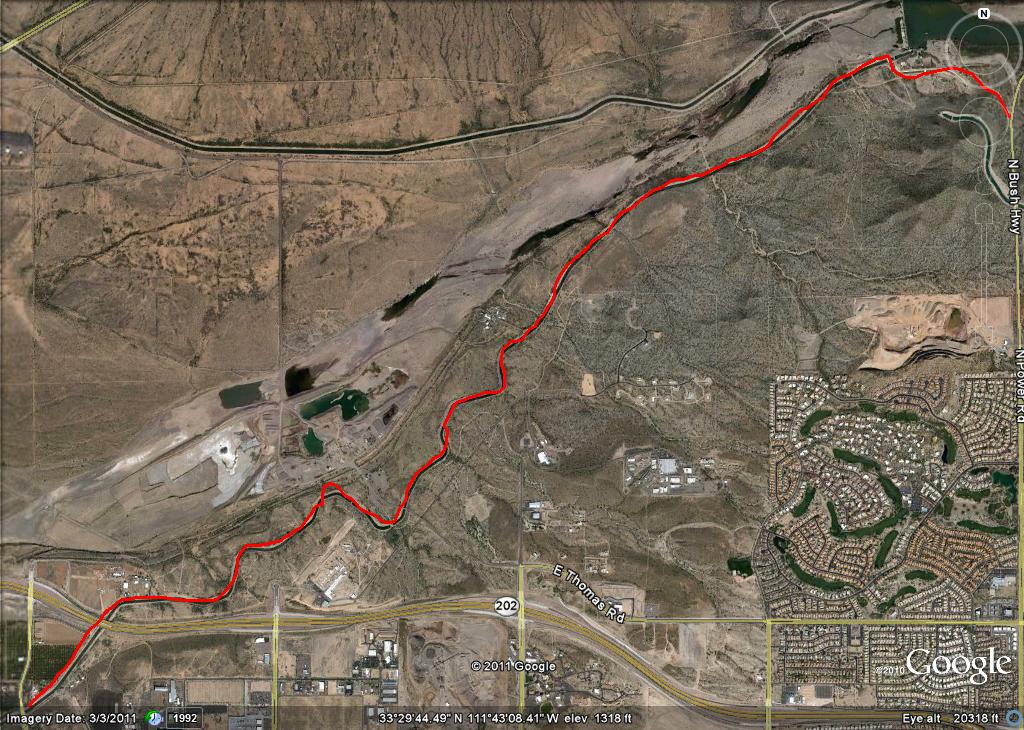
Here's a route that inadvertently connects to some of the Mesa Canals entries, and also passes the Lehi monument (First in the Mesa Canals series). I'd just planned to ride out past the monument today, which meant riding out the Eastern Canal (Mesa Canals 2) to McDowell Road, where I doglegged north to Lehi Road. Ride Lehi as soon as you can, because the orange groves are quickly disappearing into subdivisions. I predict that by this time next year, the road will be wider, and these subdivisions will be much more developed. On Lehi Road halfway between McDowell and Val Vista Roads is the "bridge to nowhere" over the North Loop 202 (actually, it crosses to an orange grove)--it achieved a dubious notoriety when the North Loop 202 opened several years ago. This road is also the Lehi Trail to the monument beside the Salt River bed.
Cross the bridge, and turn right onto the dirt section beside the bridge that is marked as the Lehi Trail. Watch out for the ruts on the left! Also watch out for the horse gate through the fence. The dirt trail parallels the river, with great views of Four Peaks, the Superstitions, and the McDowells, besides Red Mountain (for my money, one of the most scenic trails in town for mountain bikes).
Continue past the monument to where Val Vista Road crosses the freeway. There is no official public gate to the road at Val Vista, but if the horse stable gate to Val Vista is open, a bicyclist can put his or her bike through the bar fence that borders the stable drive, and just ride up Val Vista. Cross the bridge and turn on the road Lehi becomes (Thomas Road). You'll see a "No Outlet" sign. Where the road ends, the access road for the Southern Canal begins (see Mesa Canals 7). Just go west on the Southern Canal right of way, until you get to McDowell.
You'll notice the small blip at Val Vista. I hadn't decided to turn on Thomas road until about 200 yards up Val Vista. Again, this is an easy ride, and very scenic.
Thoughts and notes on bikes, books, places, academics, media and philosophy generally.
Saturday, June 9, 2012
Sunday, February 26, 2012
Mea Culpa Disney
This is to Mike Brooks and Bruce Bennett--I now have a Mickey Mouse watch. It's tasteful, with understated mouseheads etched in orange, and a black band. But it's been a very different trip with Chris this year than last year. First, always see Disney with one you love, especially if it's someone who has a good history with Disney. Yes, the shuttles are still a little slow, and yes, you still can't get anything but Disney coffee within five miles. But--props to Bruce--you can still get that $14.95 mug that you can keep refilling. With two (who actually drink from each other's cups), that's even better.
Now, a little Orwell Disney--as we entered the Magic Kingdom yesterday, they had a fingerprint machine on the turnstile (right forefinger only, in the interests of fairness). Uncle Walt is watching you!
But I now understand the attraction better. None of the rides were actually cheesy at the Magic Kingdom, and there's a real idealism about the characters that Disney has created. It's an interesting (and megalomaniacal) goal to create a new and better reality, but the Disney parks really do a good job. The irony involved in most of the exhibits created a pleasing po-mo feel most of the time. The only irony-free show was the Hall of Presidents, and the Carousel of Progress was a nostalgic look back to Disney's (relatively) irony-free take on progress (interesting idea, that you could chart the progress of the 20th century through household technology), circa the 1965 New York World's Fair.
Now, a little Orwell Disney--as we entered the Magic Kingdom yesterday, they had a fingerprint machine on the turnstile (right forefinger only, in the interests of fairness). Uncle Walt is watching you!
But I now understand the attraction better. None of the rides were actually cheesy at the Magic Kingdom, and there's a real idealism about the characters that Disney has created. It's an interesting (and megalomaniacal) goal to create a new and better reality, but the Disney parks really do a good job. The irony involved in most of the exhibits created a pleasing po-mo feel most of the time. The only irony-free show was the Hall of Presidents, and the Carousel of Progress was a nostalgic look back to Disney's (relatively) irony-free take on progress (interesting idea, that you could chart the progress of the 20th century through household technology), circa the 1965 New York World's Fair.
Friday, February 24, 2012
Bicycle Telemetry
Got a Garmin Edge 500 for Christmas (thanks, Beth and Steve)! Now, I've had bicycle computers before, but the level of telemetry associated with this one is exhilarating: speed (of course), as well as average and max speeds, a record of the route, calories burned, cadence [yes, I got the accessory], heart rate [yes, again]. But that isn't the full picture. The computer (which is surprisingly well-designed for multiple bikes) also allows one to save workouts and courses, which it then lets you replay to do specific interval/cadence/fitness workouts whenever you need to, or check your performance on saved courses against a standard.
So, what's the issue? None at all, except that I get entranced and obsessed with the record-keeping side. I ride early in the morning, when it's still dark, and constantly checking my data threatens to involve me in a crash when I attempt to shift between screens on the computer, or turn on the backlight. I've become aware that my obsession has some negative elements.
It did take a while to set up the machine--learning how to connect the accessories, configuring the information screens, setting up bicycle profiles, and so on. But there's more; I personally am constantly tempted to check all my data at any given moment. One morning, I was so obsessively trying to get all to work right (worrying about my low heart rate alarm, checking my cadence) that I literally did not remember the first mile of my ride. And this ride crossed a major intersection with a stoplight that has sensor problems, so I'm sometimes forced to cross it against the signal.
One of the reasons I ride early is to reset myself mentally and physically for my day. I love the routes and views as the light begins to grow in the morning. I remind myself of what is really important: experiences in which I am completely present, experiences that enhance my personal discipline and health, experiences of natural beauty, time for spiritual contemplation. So, I have needed to put my telemetry into perspective as well. This perspective was helped by the fact that I had inadvertently left my computer at our Mexican beach cabin (where I was using it to map my running workouts--did I mention that the routes can be pictured on Google Earth? See--waaaaay too fun!). Anyhow, when I got it back (thanks, David and Debbie!), I decided to be more disciplined in my use. That's another strength of the device; I can turn it on and forget it until the end of the ride. Now I do that, and analyze my workout later. If I need to know my speed or my cadence, I glance when the streetlight's on the computer. But I still need to turn off the audible low heart rate alarm.
So, what's the issue? None at all, except that I get entranced and obsessed with the record-keeping side. I ride early in the morning, when it's still dark, and constantly checking my data threatens to involve me in a crash when I attempt to shift between screens on the computer, or turn on the backlight. I've become aware that my obsession has some negative elements.
It did take a while to set up the machine--learning how to connect the accessories, configuring the information screens, setting up bicycle profiles, and so on. But there's more; I personally am constantly tempted to check all my data at any given moment. One morning, I was so obsessively trying to get all to work right (worrying about my low heart rate alarm, checking my cadence) that I literally did not remember the first mile of my ride. And this ride crossed a major intersection with a stoplight that has sensor problems, so I'm sometimes forced to cross it against the signal.
One of the reasons I ride early is to reset myself mentally and physically for my day. I love the routes and views as the light begins to grow in the morning. I remind myself of what is really important: experiences in which I am completely present, experiences that enhance my personal discipline and health, experiences of natural beauty, time for spiritual contemplation. So, I have needed to put my telemetry into perspective as well. This perspective was helped by the fact that I had inadvertently left my computer at our Mexican beach cabin (where I was using it to map my running workouts--did I mention that the routes can be pictured on Google Earth? See--waaaaay too fun!). Anyhow, when I got it back (thanks, David and Debbie!), I decided to be more disciplined in my use. That's another strength of the device; I can turn it on and forget it until the end of the ride. Now I do that, and analyze my workout later. If I need to know my speed or my cadence, I glance when the streetlight's on the computer. But I still need to turn off the audible low heart rate alarm.
Wednesday, February 15, 2012
Mesa Canals 8: Roosevelt Canal and Maricopa Floodway, University to Baseline
It should have been a lot more fun than this. In Mesa Canals 5 and 6, I rode the Roosevelt Canal to where it meets the Southern Canal. I remember looking southeast from where I stopped at University Avenue, and thinking that the floodway park and canal looked like ideal places to ride. Well . . . here's the approximately 4 1/2 miles from University to Baseline that I rode on Sunday, February 12, 2012.
The first half-mile, from University to Main, was still very nice. The path through the floodway is macadamized (the small pebbles are stuck together with tar, making a light road-like surface), and the entrances from the major roads are narrow. I was riding my mountain bike, and always unclipped a foot from the pedals to have a bit more stability as I inched my way between the pipes. I guess that's fine, in that it slows the bicycle traffic and keeps motorized vehicles out. The canal and floodway, however, cross Main Street exactly at its intersection with Higley Road; it takes some looking around to see where the floodway trail goes. A rider or walker has to cross two main streets to get to the side of the road where the trail continues.
It actually crosses behind a U-Mart (see the picture on the right), to continue. The pathway is still well-paved, and some prefabricated senior dwellings actually have yards that front the canal, with no fencing. This must be nice for the older person who wants to walk his or her small dog straight out the door. And there are plenty of older people and dogs, most of them small (the dogs, that is) walking and running through the grass of the spillway.
When one gets to the Broadway intersection, however, the true geriatric fun starts. It seems that S . . . I mean, Leisure World has blocked off access to the floodway because they built a golf course in it. I mean, OK, so they were here first, and they basically cordoned off a four square mile stretch of property (so that no public mile road goes through the area, and there's no freeway entrance), but to cut off access to the canal and the floodway? Here's how it is: the golf course cuts off the floodway, so I took to the east bank of the canal. At Southern, the east bank dead-ends at a floodway junction, and the east bank of the floodway is fenced up to the very edge(again, by S . . . I mean, Leisure World), so I cross the floodway junction to the canal access, where the east bank of the canal continues until it is cut off by a fence that stretches across the flat. One can swing around the edge of the fence over the steep part of the bank relatively easily if one is a walker. With a bicycle, it is just a little dicey, though it can be done. So, a tip. Take the west bank of the canal past the Broadway junction, and you'll get along fine until Southern Avenue. (By the way, enlarging the Google Earth picture at the top will give a sense of all the casting about I did, trying to find a route through the floodway. It will also show where I had to cross the canal south of the freeway).
In fairness, I do have to mention that at the golf course fence on Broadway, there is a retention pond of some kind for the course, which contains a flock of white cranes (see the picture at the left). A big flock, and a beautiful sight.
Past Southern, I originally went out the west bank of the canal, because the entrance was clearer. It's kind of fun to go under the huge superhighway that the U.S. 60 has become. There's an SRP equipment yard just north of the freeway, and a fenced pump and lock unit just south of the underpass. The West bank of the canal is closed at this point. Thankfully, the lock is not blocked off, so it is possible (again, with difficulty) to walk one's bike across to the east bank. I continued down the east bank of the canal to Baseline Road, where I stopped, seeing new construction of yet another golf course in the floodway.
So, the way to get through most efficiently: Take the floodway to Broadway, then take the west bank of the canal to Southern (there is better bicycle access around fences on the western bank [see below]), then switch to the east bank to get down to Baseline. Really, though, the bottom line is that it was a beautiful day, and I explored several more miles of the canal system.
Saturday, October 1, 2011
Mesa Canals 7: Val Vista Road to Granite Reef Dam on the Southern Canal

In a way, this is the big one: 4.9 miles from the junction of the Southern Canal and Val Vista Road to a bridge at the spillway of the dam. From the bridge to the Bush Highway on Granite Reef Dam Road is a further .8 mile. The 5.7 total miles recorded on my odometer track perfectly with the 5.66 miles of the Google Earth Route. It seemed longer. Wait. That didn't sound right--the surface is often rough on the north side of the canal (which you want to use, for reasons that will become clear later), but there is great scenery and no major road crossing.
Early in the ride, which I undertook in the early morning, the canal crosses under the 202 freeway. A bobcat was ambling down the path, coming out from an orange grove where he'd almost certainly spent the night. Past the orange grove on the north side of the 202, the canal goes through Pima reservation land on one side. On the other side are other isolated homesteads (including one fenced one with interesting signs) and a gravel operation. When the path gets close to the dam, the south side of the canal is cut down through the rock of some slopes, and there's no trail on that side. At the dam spillway, I saw cows grazing; a bridge allowed me to cross the canal to Granite Reef Dam Road, which leads out to the Bush Highway (coming the other direction last week, there are a number of Keep Out signs on Granite Reef Dam Road, but the road itself is not blocked).
The Bush Highway climbs steeply back up to McDowell Road, which is a good route back west to Mesa.
Mesa Canals 6: Connecting the Dots
This is a bit out of place, but I wanted to connect a couple of routes that I've previously described. In Mesa Canals 5, I pointed out that I'd wanted to go North on the Roosevelt Canal past McDowell, but that the path didn't look open. However, it actually was (see the picture below). On (apparently) August 13, I set out to complete the mile of canal path that I hadn't done.

First, the total route is approximately .8 of a mile (by my odometer). The first portion of the path goes past orange groves and some kind of industrial yard. After a while, one comes upon some relatively rural property east of Val Vista Road. On the road there are subdivision gates, but on the canal path, there seem to be a couple of dirt roads in, with some ranches essentially fronting onto the path. Here's the water tower of one.

At .6 of a mile, there's a fence, which can also be gotten through. It leads down a road to an octagonal pumping station at the junction between the Roosevelt and Southern Canals. About 200 yards west, the trail meets Val Vista Road. Here's the Google Earth picture of the path. By the way, this route connects up with other route described in Mesa Canals 5, and Mesa Canals 7.

Last week, I tried to connect one other route. About 3 weeks ago, I'd ridden the Southern Canal all the way out to Granite Reef Dam. That is documented in Mesa Canals 7. But I'd started that trip at the Val Vista intersection of the Southern Canal. I wanted to document the Southern Canal connector between my Mesa Canals 2 description to McDowell Road, and the big Granite Reef Dam trip. Anyhow, the north side of the canal is open to traffic. It runs just below the works of an industrial gravel operation, the Val Vista water treatment plant, and some subdivisions north of McDowell. The scenery looking north (from near the top of the mesa) is interesting, across orange groves and incoming subdivision sites south of the 202, with the McDowell Mountains, Red Mountain, and even Four Peaks in the distance. The road has little elevation change, and is well-graded.

First, the total route is approximately .8 of a mile (by my odometer). The first portion of the path goes past orange groves and some kind of industrial yard. After a while, one comes upon some relatively rural property east of Val Vista Road. On the road there are subdivision gates, but on the canal path, there seem to be a couple of dirt roads in, with some ranches essentially fronting onto the path. Here's the water tower of one.

At .6 of a mile, there's a fence, which can also be gotten through. It leads down a road to an octagonal pumping station at the junction between the Roosevelt and Southern Canals. About 200 yards west, the trail meets Val Vista Road. Here's the Google Earth picture of the path. By the way, this route connects up with other route described in Mesa Canals 5, and Mesa Canals 7.

Last week, I tried to connect one other route. About 3 weeks ago, I'd ridden the Southern Canal all the way out to Granite Reef Dam. That is documented in Mesa Canals 7. But I'd started that trip at the Val Vista intersection of the Southern Canal. I wanted to document the Southern Canal connector between my Mesa Canals 2 description to McDowell Road, and the big Granite Reef Dam trip. Anyhow, the north side of the canal is open to traffic. It runs just below the works of an industrial gravel operation, the Val Vista water treatment plant, and some subdivisions north of McDowell. The scenery looking north (from near the top of the mesa) is interesting, across orange groves and incoming subdivision sites south of the 202, with the McDowell Mountains, Red Mountain, and even Four Peaks in the distance. The road has little elevation change, and is well-graded.
Thursday, August 18, 2011
The End of Borders
Last Saturday, Chris and I went to a dollar theater at Superstition Springs mall in Mesa Arizona. As we were leaving the theater, we noticed that the Borders Bookstore in the mall was still open. Most of the other Borders in town are shuttered, so we went in.
Signs everywhere--fixtures being sold, but shelves and shelves of books, most 30% off. We wandered the aisles doing a last check of a store that at one time or another had been a big part of both of our lives. I read that Borders was founded in 1971, in Ann Arbor Michigan. When I arrived in Ann Arbor for graduate school in 1979, I found the store immediately. In a town full of bookstores (new and used), Borders was the best. Wikipedia says that the company tailored its inventory system to fit the needs of the particular communities in which the stores were located (http://en.wikipedia.org/wiki/Borders_Group). Certainly, my ex-wife's employer, the Christian book distributor Spring Arbor, envied their inventory system. But that's beside the point. Over my decade in Ann Arbor, I must have spent several thousand graduate student dollars at that store, and hundreds of hours just roaming the shelves. I think I've said somewhere else on this blog that I had the idea of melding coffee and books while browsing at bookstores in A-squared (as we used to call it). But I'm lazy, and it took Borders itself to actually do it in the 1990's.
When I got to Tempe Arizona in 1990, the alternative bookstore Changing Hands was still on Mill Avenue, and still collected and posted bookmarks from quality bookstores across the country. They had an old Borders bookmark up (as the developers got to Mill Avenue and a Borders moved in down the street, Changing Hands was forced off the street and into South Tempe In an interesting irony, though the Mill Avenue Borders has been closed for over a year, the Changing Hands has flourished, as have other independent bookstores).
Anyhow, the tour through the aisles of the Superstition Springs Borders prompted a wave of nostalgia that left me verclempt. Chris and I had spent many happy hours in the Borders near Fiesta Mall in Mesa, and had bought several gallons of coffee there. As we wandered, we bought a C.S. Lewis Bible (apologies to Lou Markos), two books of travel writing, a video, and (for me) a book of Arizona bicycle tours. Interestingly, the prices still weren't that low. And that got me thinking--the first time I'd ever bought something on Amazon was about 1999, when it wasn't clear that online retailing would even survivie. But even then, one could hear the faint tolling of the death knell. You could find anything, new or used, on Amazon or their partners. Now, I buy almost all of my books on Amazon, bypassing even the publishers. Chris just bought me a Kindle for Father's Day, and I've been buying $10 books for it, and have been looking for PDFs for it too. We've still got shelves and shelves of books in our house, but I see the world changing ("I can feel it in the air"--Galadriel, LOTR movie, Fellowship of the Ring). I don't know what will happen over the next few years, but I'm also assembling electronic anthologies for our literature classes offered online.
Signs everywhere--fixtures being sold, but shelves and shelves of books, most 30% off. We wandered the aisles doing a last check of a store that at one time or another had been a big part of both of our lives. I read that Borders was founded in 1971, in Ann Arbor Michigan. When I arrived in Ann Arbor for graduate school in 1979, I found the store immediately. In a town full of bookstores (new and used), Borders was the best. Wikipedia says that the company tailored its inventory system to fit the needs of the particular communities in which the stores were located (http://en.wikipedia.org/wiki/Borders_Group). Certainly, my ex-wife's employer, the Christian book distributor Spring Arbor, envied their inventory system. But that's beside the point. Over my decade in Ann Arbor, I must have spent several thousand graduate student dollars at that store, and hundreds of hours just roaming the shelves. I think I've said somewhere else on this blog that I had the idea of melding coffee and books while browsing at bookstores in A-squared (as we used to call it). But I'm lazy, and it took Borders itself to actually do it in the 1990's.
When I got to Tempe Arizona in 1990, the alternative bookstore Changing Hands was still on Mill Avenue, and still collected and posted bookmarks from quality bookstores across the country. They had an old Borders bookmark up (as the developers got to Mill Avenue and a Borders moved in down the street, Changing Hands was forced off the street and into South Tempe In an interesting irony, though the Mill Avenue Borders has been closed for over a year, the Changing Hands has flourished, as have other independent bookstores).
Anyhow, the tour through the aisles of the Superstition Springs Borders prompted a wave of nostalgia that left me verclempt. Chris and I had spent many happy hours in the Borders near Fiesta Mall in Mesa, and had bought several gallons of coffee there. As we wandered, we bought a C.S. Lewis Bible (apologies to Lou Markos), two books of travel writing, a video, and (for me) a book of Arizona bicycle tours. Interestingly, the prices still weren't that low. And that got me thinking--the first time I'd ever bought something on Amazon was about 1999, when it wasn't clear that online retailing would even survivie. But even then, one could hear the faint tolling of the death knell. You could find anything, new or used, on Amazon or their partners. Now, I buy almost all of my books on Amazon, bypassing even the publishers. Chris just bought me a Kindle for Father's Day, and I've been buying $10 books for it, and have been looking for PDFs for it too. We've still got shelves and shelves of books in our house, but I see the world changing ("I can feel it in the air"--Galadriel, LOTR movie, Fellowship of the Ring). I don't know what will happen over the next few years, but I'm also assembling electronic anthologies for our literature classes offered online.
Subscribe to:
Posts (Atom)