 |
| The rim of the Painted Desert |
As of October 4, 2023, the passage has not been fully hiked or biked. In September 2023, parts of this passage were mountain biked:September 18, 2023: After a long day completing Passage 37 from the South Rim of the Grand Canyon the day before, we drove to the Grandview Fire Tower to explore south on Passage 36, doing a 3-mile out and back route (6 miles total) on the trail. Before we hit the trailhead, we visited the Kaibab National Forest Ranger Station in Tusayan. While we were there, a Navajo (Dine') couple, one a hosteen (elder), the other, his wife or daughter. As she filled out their permits to gather firewood, he pointed out various dangerous creatures on the posters: the coral snake (tł'iish) and Gila Monster (tiníle'í). I wanted to say axhe'he'e' (thank you), but I didn't know the word at the time.
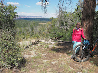
The day was clear, with temperatures in the mid-70s; the ponderosa forest was open and clear, with the trails sometimes rocky and slopes with water bars. The trail would have been moderately easy, except that I had destroyed my shoes the day before on Passage 37. With duct tape they were barely usable, and did not unclip easily (3 falls for that reason alone). There were plenty of wildflowers, and good views of the Painted Desert Rim above Marble Canyon.
 |
| Shoes and duct tape |
On our arrival back at the Grandview Fire Tower, we met three through-trail riders on hybrid gravel bikes, fully loaded, who had been traversing the Great Western Trail, which winds through western U.S. states from North to South. This trail accommodates motorized as well as foot traffic, and parallels the Arizona Trail at this point, on nearby dirt roads. One of these riders had also hiked the Arizona Trail, and said that he would hike, rather than ride, the Arizona Trail.
 |
| Lunch stop |
The link for the triplog of the North section bicycled:
https://hikearizona.com/dex2/profile.php?u=146&ID=46#T__209816_______1
 |
| Well at Moqui |
 |
| A ruined Wall |
 |
| Moqui signage |
On September 19, we drove to Moqui Stage Station, the access point to Passages 36 (S) and 35 (N). It's approximately 11 relatively easy miles on a gravel road from Highway 64. Because of the shoe issues, we had determined to hike, rather than mountain bike, the southern section of Passage 36. This was a shame, because after traversing the spur trail from Moqui, the trail followed two-track roads for as far as we went (2 miles out and back, for a total of 4 miles). The AZT bicycling guide had rated the section from Russell Tank to here as rougher mountain biking than the sections we had done, but the section we hiked did not seem to be so. Again, clear weather, temperatures in the high 70s to low 80s, wildflowers abounded. From the southern end of Passage 36, I did hike 1/4 mile farther down the beginning of passage 35.


No comments:
Post a Comment