Tuesday, October 10, 2023

Grandpa Does the Arizona Trail: Passage 34


On September 21st and 22nd, 2023, Chris and I completed about 12 miles of Passage 34, hiking ten and a half miles from south of Schultz Tank to the Snowbowl Road. The next day, parking at Snowbowl Road, we did around a mile and a quarter out and back northbound on the trail (this second day was a concession to the complications of dropoff and pickup at trail junctions, and previous overenthusiasm during the mountain biking sections.

On the 21st, we parked at the Snowbowl Road and called a taxi (!) to take us to what we thought would be the Schultz Tank Trailhead. [By the way, shout-out to Turquoise Taxi (928-600-2112)!] But it turns out that eastbound Schultz Tank Road in northwest Flagstaff has been closed near its entrance because of forest fire and flooding damage. It also turns out that Little Elden Road, which usually reaches up to the Schultz Tank Trailhead (which I had driven to during my hike of Passage 32), is now closed about two and a half miles below the trailhead. Turquoise took us as far as the closed-road gate on Little Elden Road. This turned what we thought would be a 7 1/2 mile hike into about a 10 1/2 mile hike.

We also needed to find the trail from the road. As can be seen by the route on Route Scout (https://hikearizona.com/map.php?TL=209963), the sharp right angle bend off the road is the place where we left the road and bushwacked to the Arizona Trail. There, we experienced our second instance of Native kindness, when a Native man who was cutting wood for his grandparents (part of the fire clearing program in the national forest) saw us get out of the taxi and stand around puzzled. His hunting mapping app showed where the Arizona Trail was, and confirmed Route Scout. He also encouraged us that the trail was really very close and easy to find. He must have heard my murmured "Ya-ta-he" (I thought that on balance he was probably Dine'), because he came back with two ears of pit-roasted and smoked corn from his family corn field on one of the Hopi Mesas. He said, "These are for your journey." I didn't know the word then, but now I can say to him "kwakwhay" (thank-you). It was an important blessing to receive. The corn was delicious that evening.


The rest of the day went smoothly, though the portion of Passage 32 that I had hiked many years before had been rerouted in some places, mostly up and across burned-over slopes prone to erosion. We climbed on the trail to Schultz Tank, meeting a party of equestrians on one of the slopes. We got to Schultz Tank (below) soon after lunch, seeing some small water troughs first, before seeing the tank itself. Though the roads all seem to be closed, there was some presence of RVs and camps in the area. Signs proclaimed that forest restoration was the reason for the camps in the area.


Once on Passage 34 proper, we often hiked alone, though by midafternoon, we began to be passed by mountain bikers, who seemed to have come up from a number of spur trails in the Flagstaff trail system. We probably were passed by around 8 cyclists, mostly in pairs. The terrain, though rolling, did not have any huge descents or climbs, and the trail itself was clearly marked and not too rocky.


Later in the afternoon, we passed the Flagstaff City Passage (33); soon after that, we ran into the through-hiker that we had met the day before (see my narrative of Passage 35) at Cedar Ranch Trailhead. Now we were hiking in opposite directions, and he gratefully took an apple and a bag of pretzels from us, since he was "flagging" a bit before getting into town. So, in the less than 24 hours since he'd seen us the day before, he had hiked over 25 miles. We wished him good luck and a great time in Flagstaff.

The 22nd was our last day of hiking before leaving for home. Originally, I had planned an 11-mile day on Passage, to Forest Road 417. But our week of experiences, including our shuttling issues on the first part of Passage 34, had convinced me that discretion was the better part of valor in this case, so we contented ourselves with hiking 1 1/4 miles northbound from the Snowbowl road (a 2 1/2 mile round trip). We then headed for home in Mesa.


Monday, October 9, 2023

Grandpa Does the Arizona Trail: Passage 35


Cedar Ranch Trailhead Marker

On September 20, Chris and I left our Grand Canyon National Park campsite, travelling to Flagstaff. On the way back, we scouted the south end of Passage 35 (going north), and glanced at the north end of Passage 34. After the hiking trip of yesterday at the south end of Passage 36, I decided to duct tape the shoes one more time for a little bit of riding on Babbitt Ranch, which was reputed to be some of the easiest riding on the AZT. And it was, at least the 4-mile section that we rode out and back from the Cedar Ranch Trailhead.

The adventure started early: the Cedar Ranch Road is unmarked at the entrance, which also proclaims it a "commercial road with no through access, not for passenger car traffic." (So, probably it does have through access to the 89, and it's well-graded, so passenger cars can easily navigate it.) We stopped for a while to get our bearings. Thanks to the poor road grader who waited for a while for us to go, then started out, back down the road. The Cedar Ranch trailhead is about 7 miles in on this road, past a turnoff to Cedar Ranch itself, and through a cattle gate. Turns out that along the road is all open cattle range.

The south end of Passage
35, from the trailhead.

The north end of Passage
34, from the trailhead,


Unfortunately, I used the "Delete Drive Out" feature in Route Scout on a part of the trail that I mountain biked, the south end of Passage 35. It deleted every element of the trail that was over 5 mph. So I have recreated our mountain bike route of September 20 from the Cedar Ranch trailhead below.


We did about 4 miles out; the marked route shows that the first about three miles were on Cedar Ranch Road, until the turnoff near Babbitt Lake, after which we went about one more mile (until we came to a more rocky downslope). Cedar Ranch Road was well graded, and past the turnoff a little less so, but ultimately very bikeable for beginners. We had relatively little time, some battered gear, and the Arizona Trail mountain biking guide that listed the Russell Tank section (about 10 miles north) as "intermediate." So we turned back at mile 4, making an 8-mile trip. The first of the pleasant surprises happened on our trip out on Cedar Ranch Road--a cattle roundup was going on. We'd seen cattle beyond (north of) the gate that we used to enter Passage 35, and we'd had a couple of anxious moments passing groups of open-range cattle. We'd also seen a parked horse trailer (empty) near the turnoff to Cedar Ranch Road. Now we saw a family group of cattle hands (some just children) slowly driving a herd along the road. From a safe vantage point off the road opposite the cattle drive, we waited for them to pass. On the way back, we saw them as they completed the drive.


The second pleasant surprise happened when we were loading the bikes at the trailhead after the ride: a through-hiker came along behind us and got some water from a cache near the trailhead. Apparently Trail Angels stash water along this part of the route because of the lack of water sources. I didn't get his picture or name, but he was hiking fast, and was ready to climb again into Flagstaff. He had apparently taken about two days to hike south from the Grand Canyon (about 40 miles), and he planned to resupply fully in Flagstaff. (This story has a sequel.)

Once more at the trailhead . . .


Thursday, October 5, 2023

Grandpa Does the Arizona Trail: Passage 36


The rim of the Painted Desert

As of October 4, 2023, the passage has not been fully hiked or biked. In September 2023, parts of this passage were mountain biked:

September 18, 2023: After a long day completing Passage 37 from the South Rim of the Grand Canyon the day before, we drove to the Grandview Fire Tower to explore south on Passage 36, doing a 3-mile out and back route (6 miles total) on the trail. Before we hit the trailhead, we visited the Kaibab National Forest Ranger Station in Tusayan. While we were there, a Navajo (Dine') couple, one a hosteen (elder), the other, his wife or daughter. As she filled out their permits to gather firewood, he pointed out various dangerous creatures on the posters: the coral snake (tł'iish) and Gila Monster (tiníle'í). I wanted to say axhe'he'e' (thank you), but I didn't know the word at the time. 

The day was clear, with temperatures in the mid-70s; the ponderosa forest was open and clear, with the trails sometimes rocky and slopes with water bars. The trail would have been moderately easy, except that I had destroyed my shoes the day before on Passage 37. With duct tape they were barely usable, and did not unclip easily (3 falls for that reason alone). There were plenty of wildflowers, and good views of the Painted Desert Rim above Marble Canyon. 

Shoes and duct tape
On our arrival back at the Grandview Fire Tower, we met three through-trail riders on hybrid gravel bikes, fully loaded, who had been traversing the Great Western Trail, which winds through western U.S. states from North to South. This trail accommodates motorized as well as foot traffic, and parallels the Arizona Trail at this point, on nearby dirt roads. One of these riders had also hiked the Arizona Trail, and said that he would hike, rather than ride, the Arizona Trail.

Lunch stop

The link for the triplog of the North section bicycled: https://hikearizona.com/dex2/profile.php?u=146&ID=46#T__209816_______1


Well at Moqui
A ruined Wall


Moqui signage
On September 19, we drove to Moqui Stage Station, the access point to Passages 36 (S) and 35 (N). It's approximately 11 relatively easy miles on a gravel road from Highway 64. Because of the shoe issues, we had determined to hike, rather than mountain bike, the southern section of Passage 36. This was a shame, because after traversing the spur trail from Moqui, the trail followed two-track roads for as far as we went (2 miles out and back, for a total of 4 miles). The AZT bicycling guide had rated the section from Russell Tank to here as rougher mountain biking than the sections we had done, but the section we hiked did not seem to be so. Again, clear weather, temperatures in the high 70s to low 80s, wildflowers abounded. From the southern end of Passage 36, I did hike 1/4 mile farther down the beginning of passage 35.


Quite an anthill!


The link for the trip log of the South section hiked: https://hikearizona.com/x.php?x=209819


Tuesday, October 3, 2023

Grandpa Does the Arizona Trail: Passage 37


South Kaibab starting point

We began at the South Kaibab Trailhead, SOBO on September 17, 2023. Within the National Park, the AZT is not clearly marked until it becomes the Tusayan Connector Trail. The first 6-8 miles are mostly paved, though there is one AZT stretch in the national park that follows a power line maintenance road, rocky and rough. This early stretch gave us the unwarranted hope that we might be able to complete the ride in less than six hours.


One of the Arizona Trail underpasses


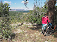
At the Tusayan turnoff, the AZT becomes two-track and single track to Grandview Lookout. Though designated "easy in the AZT bicycling guide, the two-track is actually quite rocky and rutted. This meant two things: a generally slower pace, because of having to walk bikes around obstacles (and because of the change in altitude from home), and the destruction of my (admittedly 40-year-old) touring shoes [pictured]. but the woods were open an often beautiful.


So, what we thought would be about a 6-hour tops ride ended up being about an eight-hour trip. Shuttling is an issue, since no shuttles travel between Grandview Point Overlook (near the Grandview Fire Tower). The AZT Trail Angel for this section has said that shuttles might be possible.

Our Lunch Spot outside Tusayan


But at the time, I had not thought about calling on a trail angel since I had had difficulties arranging things with other trail angels in other places, and because I (mistakenly) thought that 10 miles on Highway 64 back to the South Kaibab Trailhead (where we had left the car), would be safe and easily done. Between the shoe destruction, the onset of dusk, the tourist traffic, a lack of bike lights and general exhaustion, I ended up hitching a ride back to the car from a group of tourists at Grandview Point (thank you so much!) The trip, however, was a success, because if Emergency Services don't have to be called, how bad can it be?

Here is my RouteScout track from hikearizona.com: https://hikearizona.com/x.php?x=209797.

Grandview Fire Tower-End of the Passage


Wednesday, March 15, 2023

The Maricopa Trail--Granite Reef Dam to Usery Mountain

 At long last comes an attempt to finish off one leg of the Maricopa Trail, this time from Granite Reef Dam to Usery Mountain Park. I had hesitated to do this section for a variety of reasons: first, much of it is mountain biking, and though I am a road biker, and use my mountain bike for the canal paths, this would have been the first time in several years that I'd been on single-track, and a decade since my last serious mountain biking. Here is the county map of this leg:

https://drive.google.com/file/d/11pM_YsR5eF68XoOSP5vr_tw84vFqUEvf/view?usp=share_link.

Below is my actual route, from a Google Earth map with a GPS track (in blue):


As you can see if you compare the recorded track to the map, I have skipped about a 2-mile section of the Wild Horse Trail. The small tail on the northeast edge of the first loop, before my return to the Bush Highway represents my start on the trail. At the point I turned back, there was a one-way (downhill) sign on the trail that I was attempting to go up. Believing I had made a mistake, I went the other way on the Wild Horse Trail and ended up on the Bush Highway. I took the road up the Usery Pass hill, to the egress of the trail, and followed it west a little over a mile, then turned around, having already done 11 miles to that point. Getting back to the road, I still had about 13 miles to go to get home. I consider that I've now bicycled the route, to the Bulldog Trailhead (the green dot at the bottom right corner of the Google Earth route).

From the Bush Highway, the route turns off onto the Saguaro trail, which climbs to the Granite Ridge Trail. The Saguaro sections are moderately difficult to difficult, as is the section marked in the wilderness as "Twisted Sister." The Granite Ridge section is nice, moderate cycling. There are great views of Red Mountain on this route, and during my ride, the wildflowers were out.

My ride was a bit of a clown show--I biffed twice on easy sections, collected assorted bruises and one cut, and got both slightly bewildered and lost. I walked significant portions of the first single-track section.

The Wild Horse Trail going west, however, was generally easily rideable. A 10-minute video with views and commentary can be found here: https://youtu.be/VQ27vXvz5g4.