Showing posts with label Bicycling. Show all posts

Monday, October 9, 2023

Grandpa Does the Arizona Trail: Passage 35


Cedar Ranch Trailhead Marker

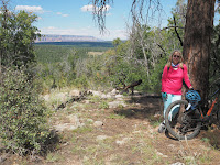
On September 20, Chris and I left our Grand Canyon National Park campsite, travelling to Flagstaff. On the way back, we scouted the south end of Passage 35 (going north), and glanced at the north end of Passage 34. After the hiking trip of yesterday at the south end of Passage 36, I decided to duct tape the shoes one more time for a little bit of riding on Babbitt Ranch, which was reputed to be some of the easiest riding on the AZT. And it was, at least the 4-mile section that we rode out and back from the Cedar Ranch Trailhead.

The adventure started early: the Cedar Ranch Road is unmarked at the entrance, which also proclaims it a "commercial road with no through access, not for passenger car traffic." (So, probably it does have through access to the 89, and it's well-graded, so passenger cars can easily navigate it.) We stopped for a while to get our bearings. Thanks to the poor road grader who waited for a while for us to go, then started out, back down the road. The Cedar Ranch trailhead is about 7 miles in on this road, past a turnoff to Cedar Ranch itself, and through a cattle gate. Turns out that along the road is all open cattle range.

The south end of Passage
35, from the trailhead.

The north end of Passage
34, from the trailhead,


Unfortunately, I used the "Delete Drive Out" feature in Route Scout on a part of the trail that I mountain biked, the south end of Passage 35. It deleted every element of the trail that was over 5 mph. So I have recreated our mountain bike route of September 20 from the Cedar Ranch trailhead below.


We did about 4 miles out; the marked route shows that the first about three miles were on Cedar Ranch Road, until the turnoff near Babbitt Lake, after which we went about one more mile (until we came to a more rocky downslope). Cedar Ranch Road was well graded, and past the turnoff a little less so, but ultimately very bikeable for beginners. We had relatively little time, some battered gear, and the Arizona Trail mountain biking guide that listed the Russell Tank section (about 10 miles north) as "intermediate." So we turned back at mile 4, making an 8-mile trip. The first of the pleasant surprises happened on our trip out on Cedar Ranch Road--a cattle roundup was going on. We'd seen cattle beyond (north of) the gate that we used to enter Passage 35, and we'd had a couple of anxious moments passing groups of open-range cattle. We'd also seen a parked horse trailer (empty) near the turnoff to Cedar Ranch Road. Now we saw a family group of cattle hands (some just children) slowly driving a herd along the road. From a safe vantage point off the road opposite the cattle drive, we waited for them to pass. On the way back, we saw them as they completed the drive.


The second pleasant surprise happened when we were loading the bikes at the trailhead after the ride: a through-hiker came along behind us and got some water from a cache near the trailhead. Apparently Trail Angels stash water along this part of the route because of the lack of water sources. I didn't get his picture or name, but he was hiking fast, and was ready to climb again into Flagstaff. He had apparently taken about two days to hike south from the Grand Canyon (about 40 miles), and he planned to resupply fully in Flagstaff. (This story has a sequel.)

Once more at the trailhead . . .


Thursday, October 5, 2023

Grandpa Does the Arizona Trail: Passage 36


The rim of the Painted Desert

As of October 4, 2023, the passage has not been fully hiked or biked. In September 2023, parts of this passage were mountain biked:

September 18, 2023: After a long day completing Passage 37 from the South Rim of the Grand Canyon the day before, we drove to the Grandview Fire Tower to explore south on Passage 36, doing a 3-mile out and back route (6 miles total) on the trail. Before we hit the trailhead, we visited the Kaibab National Forest Ranger Station in Tusayan. While we were there, a Navajo (Dine') couple, one a hosteen (elder), the other, his wife or daughter. As she filled out their permits to gather firewood, he pointed out various dangerous creatures on the posters: the coral snake (tł'iish) and Gila Monster (tiníle'í). I wanted to say axhe'he'e' (thank you), but I didn't know the word at the time. 

The day was clear, with temperatures in the mid-70s; the ponderosa forest was open and clear, with the trails sometimes rocky and slopes with water bars. The trail would have been moderately easy, except that I had destroyed my shoes the day before on Passage 37. With duct tape they were barely usable, and did not unclip easily (3 falls for that reason alone). There were plenty of wildflowers, and good views of the Painted Desert Rim above Marble Canyon. 

Shoes and duct tape
On our arrival back at the Grandview Fire Tower, we met three through-trail riders on hybrid gravel bikes, fully loaded, who had been traversing the Great Western Trail, which winds through western U.S. states from North to South. This trail accommodates motorized as well as foot traffic, and parallels the Arizona Trail at this point, on nearby dirt roads. One of these riders had also hiked the Arizona Trail, and said that he would hike, rather than ride, the Arizona Trail.

Lunch stop

The link for the triplog of the North section bicycled: https://hikearizona.com/dex2/profile.php?u=146&ID=46#T__209816_______1


Well at Moqui
A ruined Wall


Moqui signage
On September 19, we drove to Moqui Stage Station, the access point to Passages 36 (S) and 35 (N). It's approximately 11 relatively easy miles on a gravel road from Highway 64. Because of the shoe issues, we had determined to hike, rather than mountain bike, the southern section of Passage 36. This was a shame, because after traversing the spur trail from Moqui, the trail followed two-track roads for as far as we went (2 miles out and back, for a total of 4 miles). The AZT bicycling guide had rated the section from Russell Tank to here as rougher mountain biking than the sections we had done, but the section we hiked did not seem to be so. Again, clear weather, temperatures in the high 70s to low 80s, wildflowers abounded. From the southern end of Passage 36, I did hike 1/4 mile farther down the beginning of passage 35.


Quite an anthill!


The link for the trip log of the South section hiked: https://hikearizona.com/x.php?x=209819


Tuesday, October 3, 2023

Grandpa Does the Arizona Trail: Passage 37


South Kaibab starting point

We began at the South Kaibab Trailhead, SOBO on September 17, 2023. Within the National Park, the AZT is not clearly marked until it becomes the Tusayan Connector Trail. The first 6-8 miles are mostly paved, though there is one AZT stretch in the national park that follows a power line maintenance road, rocky and rough. This early stretch gave us the unwarranted hope that we might be able to complete the ride in less than six hours.


One of the Arizona Trail underpasses


At the Tusayan turnoff, the AZT becomes two-track and single track to Grandview Lookout. Though designated "easy in the AZT bicycling guide, the two-track is actually quite rocky and rutted. This meant two things: a generally slower pace, because of having to walk bikes around obstacles (and because of the change in altitude from home), and the destruction of my (admittedly 40-year-old) touring shoes [pictured]. but the woods were open an often beautiful.


So, what we thought would be about a 6-hour tops ride ended up being about an eight-hour trip. Shuttling is an issue, since no shuttles travel between Grandview Point Overlook (near the Grandview Fire Tower). The AZT Trail Angel for this section has said that shuttles might be possible.

Our Lunch Spot outside Tusayan


But at the time, I had not thought about calling on a trail angel since I had had difficulties arranging things with other trail angels in other places, and because I (mistakenly) thought that 10 miles on Highway 64 back to the South Kaibab Trailhead (where we had left the car), would be safe and easily done. Between the shoe destruction, the onset of dusk, the tourist traffic, a lack of bike lights and general exhaustion, I ended up hitching a ride back to the car from a group of tourists at Grandview Point (thank you so much!) The trip, however, was a success, because if Emergency Services don't have to be called, how bad can it be?

Here is my RouteScout track from hikearizona.com: https://hikearizona.com/x.php?x=209797.

Grandview Fire Tower-End of the Passage


Wednesday, March 15, 2023

The Maricopa Trail--Granite Reef Dam to Usery Mountain

 At long last comes an attempt to finish off one leg of the Maricopa Trail, this time from Granite Reef Dam to Usery Mountain Park. I had hesitated to do this section for a variety of reasons: first, much of it is mountain biking, and though I am a road biker, and use my mountain bike for the canal paths, this would have been the first time in several years that I'd been on single-track, and a decade since my last serious mountain biking. Here is the county map of this leg:

https://drive.google.com/file/d/11pM_YsR5eF68XoOSP5vr_tw84vFqUEvf/view?usp=share_link.

Below is my actual route, from a Google Earth map with a GPS track (in blue):


As you can see if you compare the recorded track to the map, I have skipped about a 2-mile section of the Wild Horse Trail. The small tail on the northeast edge of the first loop, before my return to the Bush Highway represents my start on the trail. At the point I turned back, there was a one-way (downhill) sign on the trail that I was attempting to go up. Believing I had made a mistake, I went the other way on the Wild Horse Trail and ended up on the Bush Highway. I took the road up the Usery Pass hill, to the egress of the trail, and followed it west a little over a mile, then turned around, having already done 11 miles to that point. Getting back to the road, I still had about 13 miles to go to get home. I consider that I've now bicycled the route, to the Bulldog Trailhead (the green dot at the bottom right corner of the Google Earth route).

From the Bush Highway, the route turns off onto the Saguaro trail, which climbs to the Granite Ridge Trail. The Saguaro sections are moderately difficult to difficult, as is the section marked in the wilderness as "Twisted Sister." The Granite Ridge section is nice, moderate cycling. There are great views of Red Mountain on this route, and during my ride, the wildflowers were out.

My ride was a bit of a clown show--I biffed twice on easy sections, collected assorted bruises and one cut, and got both slightly bewildered and lost. I walked significant portions of the first single-track section.

The Wild Horse Trail going west, however, was generally easily rideable. A 10-minute video with views and commentary can be found here: https://youtu.be/VQ27vXvz5g4.


As of January 9, I've completed the Usery Spur of the Maricopa trail from the Bulldog trailhead through Usery Park. Some of it has been mountain-biked, but most has been walked.
Going from the Bulldog Trailhead, the trail (for mountain bikes) is easy to moderate until the trail meets the Pass Mountain Trail and the Talon Trail. Until the Wind Cave Trailhead, the mountain biking would be mostly moderate (to me) with some more advanced and difficult sections. We did meet a number of mountain bikers on this stretch, most traveling from Bulldog to the Wind Cave Trailhead.
On November 26, 2024, and again on Thursday, January 26, 2025, we hiked the short section between the Wind Cave Trailhead and the point where the Maricopa Trail intersects the Pass Mountain Trailhead to go west to the west edge of the park.
The map is not clear how the Maricopa Trail gets to the west edge of the park, but on November 13, 2024, I did mountain bike the western leg of the trail beyond the Pass Mountain Trailhead. All of these trails: the Lost Sheep, Moon Rock, Blevins, and Chainfruit (?) are easy rides. What is clear is that the Maricopa Trail follows the Lost Sheep Trail to the park visitor center.


Wednesday, September 1, 2021

Maricopa Trail: Gilbert-Queen Creek-San Tan


Here's the Maricopa Trail online map for this section.  The first part of this ride is documented in the Mesa Canals 14 post (a ride to Bergie's Coffee Shop in downtown Gilbert).  The map above goes from the turnoff point to Bergies on the Consolidated Canal, to where the Trail crosses the Loop 202 South.

Most of this part of the trail winds with the canal through new subdivisions.  The road crossings are generally safe, though there is at least one complicated crossing, I believe at Chandler/Williams Field Road, where it is necessary to wait for two stoplights.

Gilbert has landscaped and graded these canal paths well, and it is possible to ride on either side most of the way.  North of Elliot Road to the Bergies turnoff, however, riders will want to be on the West Bank of the canal; the east bank is blocked by some SRP structures.

At one time, much of this section must have looked like the section on the Pima-Maricopa Indian Community:  mostly farm fields and wide vistas.  Now, however, it is far more closed-in with surrounding subdivisions.  It is well-used, but not to the overly-trafficked point.

Click here for a short video on You Tube that gives a quick sense of this section of the trail (my action cam videos are still in test/learning mode).


Tuesday, August 31, 2021

Maricopa Trail: Scottsdale-Granite Reef-Mesa and Filling Blanks


Finally, the second installment:  this one covers most of the Scottsdale-Granite Reef-Mesa map (for which I'm now embedding links in the appropriate posts), though the Prelude post has more of it, and I still need to do the bit from Granite Reef at Bush Highway-Power Road to Usery Mountain Park (that will be added when the weather cools).

The two maps above show my routes on April 9, 2021 when I finally rode again the section of the South Canal from its intersection with the Eastern Canal at McDowell Road to the intersection point with the Consolidated Canal, and a new (to me) section from Hayden Road to the Mesa Landfill (on tribal land near SR 87).   Both of these routes were done with Chris; if I can ever get my action cam to work right, I'll have pictures and video, which I'll post. 

The top section is one that I've done before in the Mesa Canals series (posts 7 and 12), but it was good to do again.  The The South Canal is the north side of the fork intersection with the Consolidated Canal, and immediately goes down a steep slope.  Once down the slope, there is an underpass at Gilbert Road, before the canal grade goes through Lehi.  There's a surface crossing at McKellips Road, as there is again at Horne street (watch the traffic).  The trail skirts Mesa's Park of the Canals, before connecting with the Consolidated Canal just north of Brown Road.

The bottom map is a ride done May 31, 2021.  Most of this stretch is over the Pima-Maricopa Indian Community, and skirts farm fields, where we saw much wildlife, including a rattlesnake and some burrowing owls.  As with the South Canal stretch between McDowell and Granite Reef, this route feels like the country, though roads cross and there are other travelers (including riders of gravel bikes, who are apparently using the Maricopa Trail as a shortcut from Scottsdale to SR 87 (the Beeline Highway).  We stopped just before riding past the landfill, which was not aesthetically pleasing.  According to the map, the Arizona Canal skirts the northern edge of the landfill before curving back down to a surface crossing (!) of the Beeline Highway.  See the Prelude post for the Maricopa Trail section southeast of the Beeline.

So, this fills in one blank of this section (the big curve to the Consolidated Canal).  The next blank is the trail (near Hawes Loop) that leads to Usery Mountain Park.


Tuesday, May 4, 2021

Maricopa Trail: The Prelude (Scottsdale-Granite Reef-Mesa)


The Scottsdale-Granite Reef Map

This is starting more slowly and weirdly than I thought it would.  When the Maricopa Trail was announced several years ago, I started collecting maps, planning to do a project in the next year to cycle the whole trail.  But things change on the Maricopa County Parks website:  The Maricopa Trail connects in spots to the Sun Circle Trail, which I first became aware of around 8 or 9 years ago, and the maps have been changing and going away from their original website homes to different places.  So, now, the first part of my task is downloading the new maps and ordering them in my personal file.  Here's the current website home of the maps:  https://www.maricopacountyparks.net/park-locator/maricopa-trail/trail-maps/.

Chris and I thought we'd be able to cycle most of this together as well, but in October 2020, Chris injured her knee and has been rehabbing since.  She can ride now (with her new new bike [a long story]) but is not up to the multi-mile trails or the rougher park routes yet.

So . . . on March 28th of this year, we planned a shakedown trip of about 4 3/4 miles one-way from the Granite Reef Dam parking area on Power Road/The Bush Highway to the crossing of SR 87 (the Beeline Highway) along the Arizona Canal.  Here's a short test video (this was also a shakedown of my new action cam).  What we found:  the trail follows the southern shore of the canal all the way to SR 87.  It's also a relatively complicated and not well-signed route from the Bush Highway parking area past Granite Reef Dam, over a bridge, across the dam spillway, to the Arizona Canal.  Once on the canal path, however, the desert is open and relatively deserted (though we met several gravel bike riders, apparently cruising over from the Beeline).  Great views of the Pima-Maricopa native lands, as well as Red Mountain in the distance.  There's little noticeable elevation gain or loss.  It was also a lovely, sunny day, though a little hot (this is probably too hot for riding in full summer).

On April 11, we took another ride out the South Canal from near our home.  Starting from just past Gilbert road, the actual distance we rode on the Maricopa Trail was about 3.8 miles.  I've biked this stretch many times (see my Mesa Canals entries--7 and 12), as well as searching for the marker for the historic Lehi Crossing (Mesa Canals 1).  This stretch has more traffic, but also gets the Mesa city dweller out of town and into the scenery.

And so it begins (with a whimper) . . . my attempt to ride around the whole of the Maricopa Trail by the Spring of 2022.  The next challenge:  map reading.  It turns out the the spur from Granite Reef to Usery Mountain Park goes through a Tonto National Forest area locally known as Hawes Loop.  Should be interesting, though maybe not in the heat and snake mating season.

Thursday, April 29, 2021

Bike Touring with Google Maps--Palumbo Family Vineyard, Temecula, CA


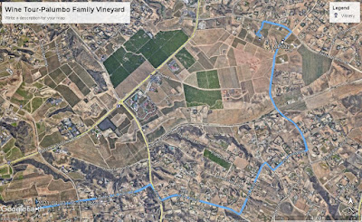
We took our mountain bikes to California when visiting family after getting vaccinated.  The main purpose of the trip was to see the grandkids under controlled outdoor conditions.  Since we could not stay with family, we found a beyond-excellent AirBnB, Rusty Fork Ranch, in the wine country around Temecula, about half an hour from an in-law family cabin.  It was just a wild hair--bike to vineyards as we had during the wine-country tour that we had done in Sonoma in 2018.  On that trip, though, despite my extensive route-planning and saving routes on Strava (not a complete success), we sometimes found ourselves on unacceptably busy roads.

So, this time, Chris said, in essence, "No riding on arterial roads with lots of traffic."  As well, the shoulders on many California roads are not what I would consider sufficient.  This wine country is also rolling, with a number of steep short hills (over 10% gradient).  So we asked our Rusty Fork host, Tyler, for a recommendation--a winery reachable by gravel road, off arterial highways, around 5 miles from the Rusty Fork.  He suggested the Palumbo Family Winery, which included a stretch on the gravel Via Fernando.

Instead of using paper maps or an app like Strava, I just entered Via Fernando on Google Maps.  That indicated a route that included only one quarter-mile stretch of arterial road (with shoulders--the Anza Road section on the map above).  Google Maps worked effectively, getting us to Via Fernando nicely; at that point, I entered the address of Palumbo Family Vineyards, and charted a course from the current location.  Perfect.

If I'd known how relatively easy using Google Maps was to find decent routes while biking, I'd have used it more extensively in 2018.  Especially helpful was the verbal direction function, which I turned on, and just put my phone back in my pocket.  It let me know what turns were coming up, and which way to go.

The Palumbo Family Vineyard was excellent in itself:  we arrived just as the tasting room opened (under COVID rules, there's only a pickup of glasses/bottles at the window, then tasting outside only, socially-distanced), and treated ourselves to a flight of reds, from which we picked two bottles to buy. Superb! (I won't tell which wines here; if you like reds, try them for yourselves.)

Just a few notes on the route:  Mountain bikes or e-bikes might be in order if you don't care to climb grades up to 11% with a high-geared road bike; though the grades are short, they are quite steep, so gear down early.  Also, be sure to bring enough water to make it for about 5 miles (the actual route is 8.95 miles from and back to the Rusty Fork).  Palumbo has water available, but there's nothing in between.  Be sure to bring something to pack the wine back in!


Tuesday, May 9, 2017

Mesa Canals 15 (plus, an update of Mesa Canals 11): To Riverview Park and Beyond!

May 9, 2017

Today, to celebrate the end of my collegiate school year, I thought I'd finish scouting to see how far the Salt River/Tempe Town Lake trail had gotten.  I had also seen (about a month and a half ago) the way Mesa was building a route around the Mesa Country Club section of the canal route that I had documented in Mesa Canals 11 (Attempted Canal Route to Mesa Riverview).

What follows is a quick review of a canal-based route to Priest Drive in Tempe, using routes that I've described in Mesa Canals 3 and 11.  First, Mesa has undertaken to improve its street bike routes as well as the canal routes greatly over the past several years (thanks, Mesa!), so the routes that I did several years ago are now all paved (mostly concrete, but some asphalt), and the intersections are at least signed, but sometimes signaled as well.  The section described in Mesa Canals 3 has now been extended to Country Club; I got a preview (that is to say that the paths I took were signed as closed), so you will want to wait for a month or two before trying them.  They are installing signals at Mesa and Country Club drives, and have completed on-street bike lanes.  However, there are still protruding small standpipes in the center of the street-bike lanes that will have to be fixed before they open officially.  After crossing Country Club, the separated street lane continues down West Brown Road until 10th Street, where the route turns off.  At the 10th Street-Alma School Road intersection, a separated bike lane continues up Alma School to Bass Pro Drive, where there is a signal.

Go down Bass Pro Drive to the roundabout, then wind through the Bass Pro Shop parking lot, closest to the freeway.  Come out of the driveway to the Jimmy Johns exit lane, then straight up Dobson until it ends (it's a little freaky to cross the mouth of the exit ramp, though there is a signal).  On the river side is the entrance to the Salt River bike path.

From there on it's paved bike paths to Priest Drive.  The initial stretch (Riverview Park, Mesa to Tempe Marketplace) does not have any road crossings; the path takes some underpasses under the 202-101 interchange.  You will pass a Salt River bird refuge, some overflow (?) settling ponds from the sewage treatment plant near the new Cubs spring training ballpark, then under the various freeway ramps (very interesting to see one's commute route from a different angle).  The first street crossing is McClintock, at one of the entrances to Tempe Marketplace (it looks like an underpass is not planned for that area).

Once you pass McClintock, you're going past Carsten Golf Course, then past the newly constructed highrises near "A" Butte.  The view is impressive--Tempe Town Lake, spanned by bridges, an expanse of shining water, bordered by parks and tall buildings (with more on the way, judging from work that's taking place east of Rural).  Though the view is impressive, one still wonders about the lake and the development; there's something incongruous about a lake in the desert, which makes Tempe look a bit like the River Charles near downtown Boston.  That's accentuated by the tall buildings that obscure "A" Butte and Sun Devil Stadium.  Call me old-fashioned, but I did prefer the butte and the nestled stadium to a monument yard of concrete and glass blocks.  But, yes, I know that here is the only place Tempe can build upwards, without running afoul of the FAA and the Sky Harbor approaches.  But did they have to be almost as tall as the butte?

I digress.  The last few miles past the high-rises to Priest Drive start out scenic.  Note a few shapes drawn by my out-and-back route:  the paved path (I did use my road bike) is bordered by a packed small gravel path for runners.  It is not always clear where to make the switch when there are road crossings or access to buildings (magnify the section between Carsten and Tempe Beach Park).

Past the Tempe Center for the Arts and the bridge over the lake near the dam, a crew was working on what looked to be an underpass under Priest Drive on the south side.  The path was closed at this point.  Foolishly, the only pictures I took were right here (there are many more photogenic spots on this ride).

From here, I backtracked to the bridge, which I crossed, then checked the paved path on the north side that also ends at Priest (maybe some other time for the trip north on the Indian Bend Wash path).  The bridge is a great view both ways.

After backtracking, I took an alternate way out, through Riverview Park (see the tail on the Google Earth picture).  Take the right fork in the path west of Dobson; you'll find yourself in a parking lot abutting the sewer treatment plant.  After finding the path on the east end of the parking lot, cross the street and thread your way through the paved paths in Riverview Park to the intersection of Dobson and Rio Salado Parkway.  Either of those two roads will take you anywhere you want to go.


May 20, 2023

It has taken a long time to get back to this section. Technically, this is not Mesa Canals any more; when we hit Tempe, it's the Tempe portion of the Salt River Path, which is said to run to Central Avenue at the Salt River and maybe beyond (the Google Earth image is not completely clear). The approximately 2 1/2 miles more that we took past the closed Priest Drive underpass described above took us to approximately south of the terminal area of Sky Harbor airport, past the 143 Freeway. The trail to this point has been well-improved, with access points, underpasses and shade structures. We (Lex, Jeff and I) stopped at this point, primarily because the day was getting hotter, and we would have done 30 miles total for the morning. At some future point, we plan to start at Tempe Marketplace and try to complete the trail to where the improvements end, or to Central Avenue, whichever is farther.

The extension, May 20, 2023

Sunday, February 28, 2016

Mesa Canals 14: Consolidated Canal to Coffee at Bergies in Gilbert


I can't believe that it's taken me almost two weeks to write this down:  I'll put it down to the flu (apparently, Arizona's the nationwide epicenter this week).  I also can't believe that this is the first Mesa Canals post in almost a year.

Anyhow, this is a great trip that I realize I haven't documented anywhere in this series, though it does intersect with Mesa Canals 10:  the Sun Circle Route for the last westbound mile.

First, this is the Consolidated Canal, which runs northwest to southeast roughly paralleling Gilbert Road.  I'd ridden this canal route before it was paved, and before the installation of traffic lights at most of the major street intersections.  Before these improvements it was iffy, and now it's approximately 8 miles of ease between 8th Street/Adobe and Bergies Coffee on Gilbert Road in downtown.  Almost the whole of the distance is paved, and almost all of the major intersections have special bike-pedestrian lights.  The two that don't (on the southern end of the route) are a little concerning, but can be used with care.

It was also a great morning, though it turned out to be unseasonably cold (probably the last time anyone will say that this year, though here's hoping).  It was a post-race warm down for Monster Media rider Beth Everhart, her Fasturdays and life partner Steve Cullen, cousin Yancy Everhart, friend Adam Burleson and me.  The East-coasters turned out to be more thin-blooded than one might think, but the sun was warm and the coffee was great!

P.S.  Beth took 3rd in the Senior Women Valley of the Sun Stage Race GC!

Friday, May 8, 2015

Mesa Canals 13 (more info on Mesa Canals 4)

Waaay back in Mesa Canals 4, I rode the Eastern Canal from where it crosses Gilbert Road to where it crosses University Avenue.  At the time, I was interested in distance, but when I rode it yesterday, I discovered a little nugget, on the west bank of the canal south of 8th Street/Adobe.  Easily reachable from the canal path, just north of an apartment complex is a small park, with synthetic climbing rocks.  It's just big enough for smaller folks, and not too hard to climb (unless you're wearing cleated shoes).  Right, see my detail map to the park in Google earth, and, below, a picture of the climbing rocks themselves.  Kudos to the city for this park!

Sunday, April 5, 2015

Mesa Canals 12: to the New Desert Trails Mountain Bike Park


On this Easter morning, after going to a sunrise service near Usery Mountain Park, I took the mountain bike out (at long last) just to ride for a while.  On the way back from the service, we had passed the new Desert Trails Mountain Bike Park at McDowell and Recker (NE corner).  So I decided to pedal out.

What a wonderful morning:  clear and 85 degrees, mountains in the distance, some wind out of the south, but not overwhelming.  I rode out on the route to Granite Reef Dam (Mesa Canals 7) to where the canal crosses the Salt River Sand and Gravel road (which becomes Thomas Road).  It's probably good to ride this on a day when there's no business traffic.  At Higley, I turned south, then went around past the Longbow Golf Course to Recker, then south on Recker to the park.

It's a decently-designed park, with a 3/4 mile perimeter trail, plus a number of BMX-style courses (some, suitable for kids).  There are apparently some trails over the hill:  the east side is for climbing, and the west side is for descending (apparently with one-way traffic).  I just tried the perimeter trails.  The only possible problem I see is that two of the downhill trails empty into the perimeter trail on the west side.  But it's very scenic, and it's great that the city has designed this relatively pristine parcel so well.

Sunday, June 29, 2014

Cycling Books for Father's Day (1)

My daughter and her boyfriend (both competitive cyclists) bought me two books for Father's Day:  Pro Cycling on $10 a Day (Phil Gaimon) (PCO$10), and Land of Second Chances:  The impossible rise of Rwanda's cycling team (Tim Lewis) (LSC).  Both are great reads, and both raise some interesting questions.  (I noticed that this is getting long, so I'll just talk about Gaimon here and save LSC for later.)

Gaimon's memoir is alternately funny and inspiring, in a post-modern sort of way:  got to love the grossness and obscenity of some of the stuff that goes on among the riders in practice, races, and training, and it's interesting to see Gaimon work through his emotions about the injustices that necessarily attend when someone is pursuing a labor of love in the context of a money-making sports environment. (Of course, ultimately he is on the cusp of getting what he set out to accomplish.  Uplifting.)

But it's most interesting to see a young one with postmodern ethics attempting to navigate the moral ambiguities of the cycling scene.  Gaimon has one ethical principle that comes to the fore:  ride clean (of performance-enhancing drugs (PEDs)).  So, we get a lot of Lance lancing (don't read this book, Armstrong, it'll make you mad).  Lance is Satan.  I understand this issue, to a point:  certainly the sport of cycling has lost much of its popularity in the U.S. thanks to this, and, to be honest, for me it's not so much Lance's actual drug use (I'm willing to give him a pass to an extent on it anyway; EPO was a survival tool during his treatment).  Instead, it's the bullying, the stonewalling, the abandonment of friends and subordinates, and the cultivated cult of personality that are ultimately the most off-putting, for me personally.  Lance's (can I say tragic? Professionally fatal?) flaw (and he has been capable of great good with the Livestrong foundation) was thus interpersonal and not behavioral.

But what Phil focuses on is the drugging.  I understand this, I understand the soap tattoo, I understand the problems of being an effective teetotaler in the company of the addicted.  And he HATES the hypocrisy of the main user pontificating self-righteously.  I get it--hypocrisy is the worst.

Phil is an example of the uniquely American moralist; American moralists run the gamut from social liberals to conservatives (and have, through American history), some tied to traditional religion, some not.  The Puritans get a bad rap, but primarily because we don't believe in the specific moral principles that they are aggressively forwarding.  But their primary moral characteristics, collectively--censoriousness and legal perfectionism--are mirrored in the discussion of almost every social issue of the last two hundred years in the nation.

This is an accident of history:  it so happens that we had a supreme and heinous evil woven into the fabric of the nation before nationhood--slavery.  That monstrous evil was fought from a moral perspective by Abolitionists of all stripes, who all tied themselves to this principle: that slavery is wrong and must be abolished.  Their methods differed:  Harriet Beecher Stowe wrote a book, Thoreau wrote an essay, harbored fugitive slaves, and spent a night in jail, John Brown attacked Harper's Ferry and was hanged.  That was the great moral principle that divided the nation, and led to 620,000 soldier casualties, besides the unrecorded number of slaves and civilians who died in the war and the centuries of slavery.  Rightly, it is a watershed moral issue, and those on the wrong side of it were (and are) vilified as monsters or despicable.

Of course, we did that with alcohol too (Prohibition), and women's suffrage, and civil rights, and gay marriage, and drugs, and speech, and names, and feminism, and smoking, and global warming (climate change?) . . . and the list goes on.  Feel free to add your own items.  One might be forgiven for thinking that some of these causes are more important than others.

But in every case, there's what I guess I'll call the rhetoric of censoriousness and dismissal.  Just think about how people talk about smokers and tobacco companies, and you get my point.  (It is, of course, the unpardonable sin [registering irony here; I have smoked a bit myself]).

Oops.  Anyhow, back to Phil:  he spends most of the book in the moralist position, but at the end is forced to confront the fact that those who were fighting alongside him on the PED issue were themselves often implicated in PED use.  I would say (as Greg Lemond has said, I think) that it was impossible to remain at the top levels of cycling any time between the mid 1980s and pretty much 2013, and not be involved in the doping scandal somehow.  I applaud Gaimon for his final reflection on the issue.

But I'm old; I was inspired by Lemond, and by Jock Boyer, Lon Haldeman, Susan Notorangelo, and others in the '80s.  I've seen a lot of ups and downs.  But that's grist for my next review.

Monday, May 19, 2014

Whoa, almost a year, really??


I looked at the date on my last blog entry and realized that it's been almost a year since I last posted.  Admittedly, I've done relatively little on the Mesa Canals lately, though I rode in the Ride the Vortex Arizona MS Society 150 ride last weekend.  It was a good ride for me, with a metric century, then a 30-mile distance over the two days.  The event was marred by a fatality on Saturday, however.  I did not find out until Saturday evening, because I did not ride that part of the course, though I have ridden that road in previous years.  The Society did not put out specific information, so I won't either, though this has been reported in news outlets.

I've also been catching up on my reading during the last two weeks out of school.  I decided on a whim to re-read Ed Abbey's Monkeywrench Gang (MG); the introduction to the edition talked about it as one of the great social issue novels of the U.S., comparing it to Uncle Tom's Cabin (UTC) and The Jungle.  Having read UTC, I can now categorically state that MG is the better-written novel by far; many of the Southwestern wilderness descriptions are positively lyrical, and as I re-read it, I also notice the classic satiric construction--there are no heroes without serious flaws in this book, and it's the case that nothing changes for the better on this issue in the book, either.  Hmmm, too much like real life?

So, why did I resonate so much more with the book this time?  (This isn't to say that I didn't resonate with the book before, given my love of the wilderness.)  But this time I personally knew the landscape Abbey was describing, having backpacked, hiked, and explored the Arizona desert for 22 years now.  When I read it first, I was living in Michigan, and the environmental degradation issues were of a different order.  It's also hard to find Western-scale wilderness anywhere east of, say Kansas and Nebraska.

Plus, now, I'm old, tired, and jaded (a regular Doc Sarvis), so the satiric structure seemed more appropriate.