Thoughts and notes on bikes, books, places, academics, media and philosophy generally.
Wednesday, February 15, 2012
Mesa Canals 8: Roosevelt Canal and Maricopa Floodway, University to Baseline
It should have been a lot more fun than this. In Mesa Canals 5 and 6, I rode the Roosevelt Canal to where it meets the Southern Canal. I remember looking southeast from where I stopped at University Avenue, and thinking that the floodway park and canal looked like ideal places to ride. Well . . . here's the approximately 4 1/2 miles from University to Baseline that I rode on Sunday, February 12, 2012.
The first half-mile, from University to Main, was still very nice. The path through the floodway is macadamized (the small pebbles are stuck together with tar, making a light road-like surface), and the entrances from the major roads are narrow. I was riding my mountain bike, and always unclipped a foot from the pedals to have a bit more stability as I inched my way between the pipes. I guess that's fine, in that it slows the bicycle traffic and keeps motorized vehicles out. The canal and floodway, however, cross Main Street exactly at its intersection with Higley Road; it takes some looking around to see where the floodway trail goes. A rider or walker has to cross two main streets to get to the side of the road where the trail continues.
It actually crosses behind a U-Mart (see the picture on the right), to continue. The pathway is still well-paved, and some prefabricated senior dwellings actually have yards that front the canal, with no fencing. This must be nice for the older person who wants to walk his or her small dog straight out the door. And there are plenty of older people and dogs, most of them small (the dogs, that is) walking and running through the grass of the spillway.
When one gets to the Broadway intersection, however, the true geriatric fun starts. It seems that S . . . I mean, Leisure World has blocked off access to the floodway 
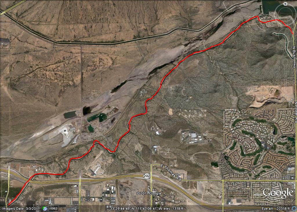
because they built a golf course in it. I mean, OK, so they were here first, and they basically cordoned off a four square mile stretch of property (so that no public mile road goes through the area, and there's no freeway entrance), but to cut off access to the canal and the floodway? Here's how it is: the golf course cuts off the floodway, so I took to the east bank of the canal. At Southern, the east bank dead-ends at a floodway junction, and the east bank of the floodway is fenced up to the very edge(again, by S . . . I mean, Leisure World), so I cross the floodway junction to the canal access, where the east bank of the canal continues until it is cut off by a fence that stretches across the flat. One can swing around the edge of the fence over the steep part of the bank relatively easily if one is a walker. With a bicycle, it is just a little dicey, though it can be done. So, a tip. Take the west bank of the canal past the Broadway junction, and you'll get along fine until Southern Avenue. (By the way, enlarging the Google Earth picture at the top will give a sense of all the casting about I did, trying to find a route through the floodway. It will also show where I had to cross the canal south of the freeway).
In fairness, I do have to mention that at the golf course fence on Broadway, there is a retention pond of some kind for the course, which contains a flock of white cranes (see the picture at the left). A big flock, and a beautiful sight.
Past Southern, I originally went out the west bank of the canal, because the entrance was clearer. It's kind of fun to go under the huge superhighway that the U.S. 60 has become. There's an SRP equipment yard just north of the freeway, and a fenced pump and lock unit just south of the underpass. The West bank of the canal is closed at this point. Thankfully, the lock is not blocked off, so it is possible (again, with difficulty) to walk one's bike across to the east bank. I continued down the east bank of the canal to Baseline Road, where I stopped, seeing new construction of yet another golf course in the floodway.
So, the way to get through most efficiently: Take the floodway to Broadway, then take the west bank of the canal to Southern (there is better bicycle access around fences on the western bank [see below]), then switch to the east bank to get down to Baseline. Really, though, the bottom line is that it was a beautiful day, and I explored several more miles of the canal system.
Saturday, October 1, 2011
Mesa Canals 7: Val Vista Road to Granite Reef Dam on the Southern Canal

In a way, this is the big one: 4.9 miles from the junction of the Southern Canal and Val Vista Road to a bridge at the spillway of the dam. From the bridge to the Bush Highway on Granite Reef Dam Road is a further .8 mile. The 5.7 total miles recorded on my odometer track perfectly with the 5.66 miles of the Google Earth Route. It seemed longer. Wait. That didn't sound right--the surface is often rough on the north side of the canal (which you want to use, for reasons that will become clear later), but there is great scenery and no major road crossing.
Early in the ride, which I undertook in the early morning, the canal crosses under the 202 freeway. A bobcat was ambling down the path, coming out from an orange grove where he'd almost certainly spent the night. Past the orange grove on the north side of the 202, the canal goes through Pima reservation land on one side. On the other side are other isolated homesteads (including one fenced one with interesting signs) and a gravel operation. When the path gets close to the dam, the south side of the canal is cut down through the rock of some slopes, and there's no trail on that side. At the dam spillway, I saw cows grazing; a bridge allowed me to cross the canal to Granite Reef Dam Road, which leads out to the Bush Highway (coming the other direction last week, there are a number of Keep Out signs on Granite Reef Dam Road, but the road itself is not blocked).
The Bush Highway climbs steeply back up to McDowell Road, which is a good route back west to Mesa.
Mesa Canals 6: Connecting the Dots
This is a bit out of place, but I wanted to connect a couple of routes that I've previously described. In Mesa Canals 5, I pointed out that I'd wanted to go North on the Roosevelt Canal past McDowell, but that the path didn't look open. However, it actually was (see the picture below). On (apparently) August 13, I set out to complete the mile of canal path that I hadn't done.

First, the total route is approximately .8 of a mile (by my odometer). The first portion of the path goes past orange groves and some kind of industrial yard. After a while, one comes upon some relatively rural property east of Val Vista Road. On the road there are subdivision gates, but on the canal path, there seem to be a couple of dirt roads in, with some ranches essentially fronting onto the path. Here's the water tower of one.

At .6 of a mile, there's a fence, which can also be gotten through. It leads down a road to an octagonal pumping station at the junction between the Roosevelt and Southern Canals. About 200 yards west, the trail meets Val Vista Road. Here's the Google Earth picture of the path. By the way, this route connects up with other route described in Mesa Canals 5, and Mesa Canals 7.

Last week, I tried to connect one other route. About 3 weeks ago, I'd ridden the Southern Canal all the way out to Granite Reef Dam. That is documented in Mesa Canals 7. But I'd started that trip at the Val Vista intersection of the Southern Canal. I wanted to document the Southern Canal connector between my Mesa Canals 2 description to McDowell Road, and the big Granite Reef Dam trip. Anyhow, the north side of the canal is open to traffic. It runs just below the works of an industrial gravel operation, the Val Vista water treatment plant, and some subdivisions north of McDowell. The scenery looking north (from near the top of the mesa) is interesting, across orange groves and incoming subdivision sites south of the 202, with the McDowell Mountains, Red Mountain, and even Four Peaks in the distance. The road has little elevation change, and is well-graded.

Thursday, August 18, 2011
The End of Borders
Last Saturday, Chris and I went to a dollar theater at Superstition Springs mall in Mesa Arizona. As we were leaving the theater, we noticed that the Borders Bookstore in the mall was still open. Most of the other Borders in town are shuttered, so we went in.
Signs everywhere--fixtures being sold, but shelves and shelves of books, most 30% off. We wandered the aisles doing a last check of a store that at one time or another had been a big part of both of our lives. I read that Borders was founded in 1971, in Ann Arbor Michigan. When I arrived in Ann Arbor for graduate school in 1979, I found the store immediately. In a town full of bookstores (new and used), Borders was the best. Wikipedia says that the company tailored its inventory system to fit the needs of the particular communities in which the stores were located (http://en.wikipedia.org/wiki/Borders_Group). Certainly, my ex-wife's employer, the Christian book distributor Spring Arbor, envied their inventory system. But that's beside the point. Over my decade in Ann Arbor, I must have spent several thousand graduate student dollars at that store, and hundreds of hours just roaming the shelves. I think I've said somewhere else on this blog that I had the idea of melding coffee and books while browsing at bookstores in A-squared (as we used to call it). But I'm lazy, and it took Borders itself to actually do it in the 1990's.
When I got to Tempe Arizona in 1990, the alternative bookstore Changing Hands was still on Mill Avenue, and still collected and posted bookmarks from quality bookstores across the country. They had an old Borders bookmark up (as the developers got to Mill Avenue and a Borders moved in down the street, Changing Hands was forced off the street and into South Tempe In an interesting irony, though the Mill Avenue Borders has been closed for over a year, the Changing Hands has flourished, as have other independent bookstores).
Anyhow, the tour through the aisles of the Superstition Springs Borders prompted a wave of nostalgia that left me verclempt. Chris and I had spent many happy hours in the Borders near Fiesta Mall in Mesa, and had bought several gallons of coffee there. As we wandered, we bought a C.S. Lewis Bible (apologies to Lou Markos), two books of travel writing, a video, and (for me) a book of Arizona bicycle tours. Interestingly, the prices still weren't that low. And that got me thinking--the first time I'd ever bought something on Amazon was about 1999, when it wasn't clear that online retailing would even survivie. But even then, one could hear the faint tolling of the death knell. You could find anything, new or used, on Amazon or their partners. Now, I buy almost all of my books on Amazon, bypassing even the publishers. Chris just bought me a Kindle for Father's Day, and I've been buying $10 books for it, and have been looking for PDFs for it too. We've still got shelves and shelves of books in our house, but I see the world changing ("I can feel it in the air"--Galadriel, LOTR movie, Fellowship of the Ring). I don't know what will happen over the next few years, but I'm also assembling electronic anthologies for our literature classes offered online.
Saturday, July 9, 2011
Mesa Canals 5: Roosevelt Canal and Maricopa Floodway, University to McDowell

I certainly picked an interesting day to do this ride--the middle of the monsoon, just after the big Phoenix haboob (don't you love that word?). Anyway, it's not too bad at 5:30 a.m., but after about 6:30 it gets a bit sticky. Google Earth says this is the Roosevelt Canal, but I probably should check that. It's between Greenfield and Higley (East-West) and I cycled (trending northwest) from University Drive to McDowell Road Here's the University Drive entrance to what is both the canal right-of-way and a Maricopa County Floodway park and trail.

I entered the canal/floodway route at 8th Street/Adobe, the great all-purpose Mesa east-west connector as far as about Ellsworth Road. At that point, the canal itself was severely restricted (impassible fences), but the adjoining bank of the floodway, across from the paved path, was open. Interestingly, the floodway trail continues southeast from where I started (this will be a future bicycling project, when I have a little more time). To the right is a picture facing southeast from University Drive.
The route itself as described and pictured is 3.3 miles (by my odometer) from University to McDowell Road. The first mile and a half (to north of Brown Road) is specifically the floodway trail, on the east side of the canal-floodway complex. The current trail is a slightly macadamized gravel (a change from the past, when it was merely gravel) with brick accents at road crossings. The trail uses restrictive fencing (relatively narrowly-spaced fencepoles) to keep out vehicular traffic. With care, mountain or road bicycle handlebars can fit through these narrow openings. More problematic is the fact that some of the brickwork is raised from the trail level at these restrictive entrances, so that an unsprung bicycle might be stopped in places. I usually unclip one foot.
About a quarter to a half mile north of Brown Road, the floodway ends, and the trail continues on the side of the canal. To this point, the trail has been landscaped, contoured and scenic. I saw a number of people running, cycling, and exercising their dogs, some in the floodway itself. Past the crossing of Greenfield Road, the canal bank is generally unimproved coarse gravel, and even more restrictive gates block the street crossings. Often, the entrances to the canal path are even hidden from general view; the explorer will have to look closely. Past Greenfield Road, the canal bank takes on a familiar character--generally a little unkempt, an alley between the back walls of subdivisions. However, between Brown and McDowell, there are still a few orange groves, along with what appear to be roads into gated communities, inaccessible from the public paved roads in the area.
I stopped at McDowell: at first glance, it looked as though the canal north was completely closed off. Since the floodway had ended, SRP had signed all street crossings relatively threateningly for "trespassers" and vehicular traffic. The last two pictures here show the McDowell canal crossing looking south (with the sign) and looking north. Notice the picture on the right. If one looks straight on, there seems to be no entrance to the canal. However, when one looks closely travelling west on McDowell, there is a way in. I will have to re-examine some other canal routes that seemed to be closed. The Roosevelt Canal north of McDowell is also a project for another day.
Friday, June 10, 2011
Ode: Intimations of Mortality
As I sit in a relatively uncomfortable chair in an 8th floor hospital waiting room, I consider that this is a relatively different challenge than the one I was expecting to face today. I was visiting my parents preparatory to attending a martial arts camp in Missouri, when my dad had a heart attack. Now he has a history of heart disease going back 34 years, to his first massive heart attack, and his continued survival (he's almost 80) is a miracle. In the event, it was providential that I was here, to call 911 and ferry my mother to and from the hospital. My parents were, in fact, well prepared for this eventuality, with detailed lists of my dad's medical history and medications. The first responders were impressed. But that's not my topic at the moment.
I find myself in my high school hometown, a 55-year-old with a CPAP machine and cholesterol medication. I'm surrounded by pictures of my grandparents in various venues, many of which (the venues, that is) I recognize. I remember my grandparents as old, but I now see that, for one set of them at least, when these pictures were taken, they were the same age as I am now.
I look at my sister, two years younger. She shows some specific signs of middle age (far be it from me to list them here.) I've been fighting this sense that I am now among the old, but being surrounded by so much of my past, it is difficult to escape the sense that I am aging. I still feel 30 or so, despite a few aches, pains, and pounds. But everyone else has worn down. How did that happen? I know (intellectually) that it all wears to an end at last, that things slow down, that the center does not hold, but I'm having to confront this young image of myself. I think-- "All I need to do is exercise some, lose a few pounds, and the clock will turn back." But it ain't necessarily so. One of my brothers-in-law, a few years older, has always seemed young, and has never had heart problems. Until three months ago.
Surrounded by aging and illness certainly points the issue of mortality. Someone said "Old age isn't for sissies," and I have a new appreciation for that, revisiting my old hometown and watching over my dad.
Sunday, April 24, 2011
Time, Education, and the Liturgical Year
I got back from our church's Easter early-morning (not sunrise at 7:30) service a couple of hours ago. The theme was "Scarred," a carry-over from a sermon series which will continue next week. The service was held in the darkened sanctuary, and the activities, which included liturgical dance (a sinner and the devil) and a sermon on the scars of "Good" Friday, did not end in light (physically in the sanctuary), though the Resurrection was, of course, invoked.
As we exited, Chris pointed out that she would have preferred to have a joyful Easter service on Easter, instead of an amalgam of Good Friday and Easter on Sunday morning. That continued some thoughts that I've had over the past few years concerning the importance of time and rhythm as an element of education. I now understand the importance of the traditional liturgical year in this way as well.
One of the things contemporary American culture seems to value is compression--compression of activities, compression of our awareness into a continuous active present of stimulation (consider Tweeting, Smart Phones, and connectivity in this regard). We've become accustomed to that in our church activities as well: I have not done a survey, but it does seem that fewer churches offer a differentiated round of services during Holy Week (Palm Sunday to Easter Sunday). Instead, we worship as though Easter comes out of nowhere (and, yes, in a sense it does) and has no context in Palm Sunday, Passover, and Good Friday. Certainly our church has moved in that direction over the last couple of years. I miss the rhythm of the liturgical year, which mirrors the rhythm of the natural year that we also tend to ignore.
So what does this have to do with education? I believe we ignore the rhythms of real education in the same way. Over a decade ago, I advanced the idea (at GCU) that there was a rhythm to higher education, which I defined as "knowledge acquisition, knowledge application, and reflection on knowledge." Of these three elements, we concentrate on acquisition, and occasionally on application (in internships), but have given little to no attention to reflection. That pattern has only intensified at the university, and in higher education in general over the last decade. I believe that we miss important elements of the educational experience, and important elements of the rhythm of life when we ignore reflection, especially.
Subscribe to:
Posts (Atom)